

Questions about platting?
- Laura Dietrich, Planning and Zoning Coordinator (402) 444-7924
- Environmental Services main line (402) 444-6181
15335 West Maple Road, Suite 201, Omaha, NE 68116 · Monday–Friday, 8:00 am–5:00 pm
Frequently downloaded documents
Article I: Title & Purpose
Section I.1: Title and Authority
This section of the Douglas County Land Use Regulations shall be known and may be cited as the Douglas County Subdivision Regulations. This chapter restates the Board's statutory authority and mandate with regard to subdivision of land and improvements thereon pursuant to Nebraska Revised Statutes §23-372 through 377.
Section I.2: Intent and Policy
The procedure by which land is subdivided into blocks and lots is a matter of great mutual concern to the subdivision applicant and the County. The street pattern, the size of lots and the utilities installed usually become permanent features of the community so that mistakes in subdivision development may cause great financial loss to the applicant and continual excessive maintenance expense to the County.
- A.It is the intent and policy of this regulation to regulate the subdivision of land in conformance with the Comprehensive Plan so as to provide appropriate open space and protection of natural features consistent with the conservation design requirements of the Comprehensive Plan and Article 7 of the Zoning Regulations, functional street layouts; adequate sized lots which are in conformity with the highest and best use of the land; adequate open spaces for recreation, schools, and traffic; adequately sized utilities and adequately improved streets; and other features of the Comprehensive Plan – primarily consistent with conservation design and that the development of land may proceed in an orderly manner with good livable neighborhoods and that the needed community facilities may be created and excessive County maintenance expense may be avoided.
- B.Implementation of this regulation is intended to protect and provide for the public health, safety and general welfare of the residents of the County by helping ensure adequate light, air, and privacy; to secure safety from fire, flood, and other danger; and to prevent overcrowding of the land and undue congestion of population. Further, to protect the character and social and economic stability of the county while respecting private property rights and to protect and conserve the value of land, buildings and improvements upon the land while minimizing the conflicts among the uses of lands and buildings in a manner consistent with the basic principles of the Comprehensive Plan.
Section I.3: Public Purpose
Regulation of the subdivision of land and the attachment of reasonable conditions to land subdivisions is an exercise of valid authority granted by the State to this County. The applicant has the duty of compliance with reasonable conditions laid down by the Board for design, dedication, improvement, and restrictive use of the land to conform to the physical and economic development of the county and to the health, safety, and general welfare of the future lot owners in the subdivision and the community at large.
Article II: General Provisions
Section II.1: Jurisdiction and Enactment
This regulation shall apply to all unincorporated areas within the County where cities and villages do not exercise zoning control. In order that land may be subdivided in accordance with these purposes and policies, this regulation is hereby adopted and made effective as of the date of approval by the County Board. All applications for subdivision approval pending on the effective date of this subdivision regulation shall be reviewed under this regulation, except that this regulation will not apply if preliminary plat approval was obtained from the County Board prior to the effective date of this subdivision regulation.
Section II.2: Repeal
This regulation repeals and replaces all prior subdivision regulations of the County.
Section II.3: Relationship to other Regulations and Laws
If municipal, county, state or federal laws or regulations or future county resolutions impose additional standards on land use within the unincorporated areas of the County, the more restrictive standard of the entity with legal jurisdiction shall apply.
Section II.4: Application
Every owner of any lot, tract, or parcel of land within the County, outside the subdivision jurisdiction of any city or village, who may hereafter subdivide the same into two or more lots, sites or other divisions of land for the purpose, whether immediate or future, of transfer of ownership or building development shall submit a subdivision plat to the Board in accordance with this regulation and comply with all other provisions of this regulation. When the smallest parcel of land created is more than twenty (20) acres in size, the division of land shall not be considered a subdivision and shall not be subject to the provisions of this section.
Section II.5: Severability Clause
If any section, subsection, paragraph, sentence, clause, phrase, provision or part or portion of any section, subsection, paragraph, sentence, clause, phrase, or provision of this regulation, or the application thereof to any person or circumstance, is held invalid or unconstitutional for any reason, such invalidity or unconstitutionality shall not affect the validity or application of any other section, subsection, paragraph, sentence, clause, phrase, provision or part or portion of this regulation.
Section II.6: Amendments
For the purpose of protecting the public health, safety, and general welfare, the Planning and Zoning Staff or Planning Commission may from time to time propose amendments to these regulations after consideration at a public meeting following public notice, which shall then be approved or disapproved by the County Board at a public meeting following public notice.
Article III: Abbreviations & Definitions
Section III.1: Abbreviation and Acronyms
- A.For the purposes of these regulations the following shall be standard abbreviations and acronyms found through the regulation.
| Abbreviation | Meaning |
|---|---|
| ADA | Americans with Disabilities Act |
| FEMA | Federal Emergency Management Agency |
| FT or ′ | Foot or Feet |
| GIS | Geographic Information System |
| IN or ″ | Inch or Inches |
| NDEE | Nebraska Department of Environment and Energy or successor department |
| NPDES | National Pollutant Discharge Elimination System |
| NRD | Papio-Missouri River Natural Resources District |
| NDOT | Nebraska Department of Transportation or successor department |
| SF | Square Feet |
| SID | Sanitary Improvement District |
| SY | Square Yard |
| USACE | United States Army Corps of Engineers |
| YD | Yard |
Section III.2: Definitions
Refer to Article 2 of the Douglas County Zoning Regulations for general definitions.
- A.For the purpose of this subdivision regulation, the following terms, phrases, words, and their derivations shall have the meaning given herein. When not inconsistent with the context, words used in the present tense include the future, words in the plural number include the singular number, and words in the singular number include the plural number. The word “shall” as used herein is mandatory and not merely directory.
- Acreage is a commonly used term for a lower density residential property and is a property which is one acre or more in size that does not qualify as a farm or agricultural property.
- Agent shall mean any person, group, corporation, partnership, or other entity representing the ownership of a tract or parcel of land.
- Alley shall mean a public right-of-way which is used primarily as a secondary means of access to the abutting property.
- Applicant shall mean the owner of land proposed to be subdivided or their representative who is responsible for any undertaking that requires review and/or approval under these regulations.
- Assessor shall mean the County Assessor of Douglas County, Nebraska.
- Attorney shall mean the County Attorney of Douglas County, Nebraska.
- Block shall mean a tract or parcel of land bounded by public streets or lands, streams, railroads, un-platted lands or a combination thereof.
- Clerk shall mean the County Clerk of Douglas County, Nebraska.
- Cluster Subdivision shall mean a development design technique that concentrates building lots within a subdivision to allow remaining land to be used for common area, or to preserve historic or environmentally sensitive features. This is applied as a “conservation subdivision” in the zoning regulations.
- Comprehensive Plan shall mean the most recent update of the Douglas County Comprehensive Development Plan for improvement and development of the County as recommended for approval by the Planning Commission and adopted by the County Board.
- Conservation Outlot shall mean an area of undeveloped land within a residential development conserved in its natural state, held in common ownership by a Homeowner’s Association with deed restrictions protecting the outlot from future development.
- Contiguous shall mean when at least one boundary line touches a boundary line or lines of another lot or parcel.
- County shall mean Douglas County, Nebraska.
- County Board shall mean County Board of Commissioners of Douglas County, Nebraska.
- County Engineer shall mean the County Engineer of Douglas County, Nebraska or an engineer retained by Douglas County for the recommendation, advice, and prosecution of engineering work.
- Cul-de-sac see Street, Cul-de-Sac.
- Dedication shall mean the intentional appropriation of land by the owner to some public use.
- Developer See applicant.
- Easement shall mean authorization by a property owner for another to use the owner’s property for a specified use.
- Frontage Road shall mean a street that is parallel and adjacent to an arterial street or highway, which reduces the number of access points to the arterial street or highway for the purpose of increased traffic safety.
- Hazard Mitigation is any sustained action taken to reduce or eliminate long-term risk to life and property from hazards.
- Improvements shall mean street grading, street surfacing and paving, curbs and gutters, streetlights, street signs, sidewalks, crosswalks, water mains and lines, water motors, fire hydrants, sanitary sewers, storm drainage facilities, culverts, bridges, public utilities, or other such installations.
- Lot shall mean real property which is or may be occupied by a use permitted by zoning regulations, together with yards and other open spaces required, that has frontage upon a street, and is a part of a recorded plat or has been recorded prior to the adoption of this regulation, or a parcel of real property delineated on survey of record, lot-split or sub-parceling map as filed in the office of the Register of Deeds and abutting or having access to at least one (1) public street or right-of-way.
- Lot of Record shall mean a tract of land described as an integral portion of a subdivision plat which is properly recorded in the Register of Deeds office of Douglas County, Nebraska.
- Monument shall mean an identification marker established by certified land survey and set by a Professional Land Surveyor at each section corner, angle point, block corner, street center line, or other point.
- Outlot shall mean a portion of a subdivision intended or reserved as a unit for public purposes or private common area that has restrictions for transfer of ownership and building development which are designate by the applicant at the time of filing of the initial plat.
- Planning Commission shall mean the Planning Commission of Douglas County, Nebraska.
- Planning Department shall mean the Planning Office within the Douglas County Environmental Services Department for Douglas County, which provides administrative support to the Planning Commission and serves as the office of the Planning Commission.
- Plat shall mean a map, drawing or chart on which the applicant’s plan of the subdivision is presented and is submitted for approval and which will be recorded in final form.
- Replat shall mean adjustment of lots previously platted within the county to allow for adjustment of interior lot lines and/or number of lots. The outer boundary of the original plat shall not be changed.
- Right-of-way shall mean a strip of land occupied or intended to be occupied by a street, crosswalk, railroad, road, electric transmission line, oil or gas pipeline, water main, sanitary or storm sewer main, shade trees, or for any other special use. The usage of the term "right-of-way" for land platting purposes shall mean that every right-of-way hereafter established and shown on a final plat is to be separate and distinct from the lots or parcels adjoining such right-of-way and not included within the dimensions or areas of such lots or parcels. Rights-of-way intended for streets, crosswalks, water mains, sanitary sewers, storm drains, shade trees, or any other use involving maintenance by a public agency shall be dedicated to public use by the maker of the plat on which such right-of-way is established.
- Setback shall mean the distance between a building and a lot or property line.
- Sidewalk or walkway shall mean that portion of a dedicated right-of-way or easement intended for pedestrian, bicycles and related non-motorized uses.
- Small Tract Subdivision shall mean the platting of a parcel into multiple lots which may or may not include the dedication of public right-of-way or easements. The number of new lots is limited to the creation of no more than 4.
- Stormwater Management Regulations shall mean the current version of regulations enacted by Douglas County for management of storm water and they shall be referred to as the “Stormwater Management Regulations” in this document.
- Street shall mean an improved surface located within a right-of-way, dedicated to public use, which affords a primary means of access to the abutting property.
- Street, Arterial shall mean a street of considerable continuity connecting various sections of the county, including, but not limited to, the county highway system.
- Street, Collector shall mean a street which carries traffic from a local street to an arterial street; a main thoroughfare.
- Street, Cul-de-sac shall mean a short public way which has only one outlet for vehicular traffic and terminates in a vehicular turn-around.
- Street, Local shall mean a street which is used primarily for access to the abutting properties.
- Street, Marginal Access shall mean a local street or frontage road which is approximately parallel to and adjacent to or part of an arterial street and provides access to the abutting properties and protection from through traffic.
- Street, Private Way shall mean an approved private right-of-way which provides primary access to one or more properties along its continuous length.
- Subdivider (aka Applicant) shall mean a natural person, firm, co-partnership, association or cooperation who submits a proposed subdivision to the County Board.
- Subdivision shall mean the division of a lot, tract or parcel of land into two or more sites, or other divisions of land for the purpose, whether immediate or future, of transfer of ownership or building development, except that the division of land shall not be considered to be a subdivision when the smallest parcel of land created is more than twenty acres in area.
- Surveyor shall mean the County Surveyor of Douglas County, Nebraska or a surveyor retained by Douglas County for the recommendation, advice, and prosecution of survey work.
- Trail shall mean paved or hard surfaced path that is a minimum of 8 feet in width, intended for pedestrian, bicycles and related non-motorized uses.
- Treasurer shall mean the County Treasurer of Douglas County, Nebraska.
- Water Course, Drainage Way, Channel or Stream shall mean a natural or man-made depression in which a current of surface run-off water flows following precipitation.
- Wetlands shall mean locations where water stands for a period of time, allowing for infiltration or evaporation potentially providing filtering of contaminants. These are not always regulated by the U.S. Army Corp of Engineers.
- Zoning Regulations shall mean the Zoning Regulations of Douglas County, Nebraska.
Article IV: Procedures
Section IV.1: Statutory Platting Requirements
- A.Pursuant to N.R.S. §23-373, no owner of real property, located in an unincorporated area, except in an area in which any city or village is exercising subdivision control, shall be permitted to subdivide, plat, or lay out of said real property in building lots, streets, or other portions of the same intended to be dedicated for public use, or for the use of the purchasers or owners of lots fronting thereon or adjacent thereto, without first having obtained the approval thereof of the board of such county. At such time as a city or village exercises such controls over an unincorporated area by adopting or amending subdivision regulations, its regulations shall supersede those of the county. All applications for subdivisions must conform with Articles V & VI in these regulations and shall be considered by the Planning Commission per N.R.S. §23.114.04 (1) prior to referral to the Board.
- B.No plat of real property described in N.R.S. §23-373, shall be recorded or have any force and effect unless the same be approved by the county board of such county. The County Board of Douglas County shall have power by resolution, to provide the manner, plan, or method by which real property in any such area may be subdivided, platted, or laid out, including a plan or system for the avenues, streets, or alleys to be laid out within or across the same including the hard surface thereof.
Section IV.2: Preapplication Meeting and Coordination
- A.Prior to the submittal of an Administrative Plat, Replat, or Preliminary Plat, the Applicant and/or his/her representative shall hold a pre-application meeting (in-person, virtual, phone call or other type as determined by Planning and Zoning Coordinator) with Planning Department Staff and any other department and/or agencies deemed necessary by the County. Notes on the meeting shall be provided by the Planning and Zoning Coordinator.
- B.Procedure for Filing Pre-application Plans and Data: Prior to the filing of an application for approval of an administrative or preliminary plat, the Applicant shall submit to county staff plans and data in sketch form showing ideas for the proposed subdivision of land. A sketch or plan on an aerial map from the current Douglas County GIS mapping system shall include:
- 1.The proposed tentative layout of streets, lots and other features in relation to existing streets, utilities, topography and other conditions. An outline of natural features and set aside areas to be protected shall be identified on the plan.
- 2.A general location map showing the proposed subdivision and its relationship to existing adjacent subdivisions and community facilities in the area, such as streets, alleys, schools, parks, commercial areas and other data supplementing the plans which outline or describe all of the proposed development as it relates to existing conditions.
Section IV.3: Administrative Plats/Replats and Administrative Boundary Changes
- A.Administrative Plats, Administrative Replats and Administrative Boundary Changes Defined
- 1.A lot line adjustment and lot consolidation as listed below are defined as administrative replats when the property involves platted parcels.
- 2.A lot and parcel merger as listed below is defined as an administrative plat when the property involves both platted and un-platted parcels.
- 3.A boundary change is defined as an administrative boundary change when the property involves only un-platted parcels.
- B.For the purpose of this Section, property owners may be eligible to seek approval to adjust an interior lot line (lot line adjustment), combine two or more lots (lot consolidation), merge platted lots and un-platted parcels (lot and parcel merger), or have a boundary change processed without traversing the lengthy subdivision process, provided the following conditions are met:
- 1.Lot Line Adjustment. A lot line adjustment is defined as the adjustment of an interior lot line between two adjoining platted lots, provided:
- a.The lots involved must have the same zoning and the proposed adjustment will not create a violation of the Zoning Regulation;
- b.The lots involved must be existing platted lots (lots in a platted, named subdivision); and
- c.No additional road right-of-way dedication is required by the County Engineer’s Office. If additional road right-of-way dedication is required, the administrative replat – lot line adjustment, shall follow the requirements for a Replat as detailed elsewhere in this Section.
- i.As a lot line adjustment results in the same number of lots, it is not required, but encouraged, that the County’s Conservation Design Regulations are followed.
- 2.Lot Consolidation. A lot consolidation is defined as the combination of two or more lots into a lesser number of lots, provided:
- a.The lots involved must have the same zoning and the proposed consolidation will not create a violation of the Zoning Regulation;
- b.The lots involved must be existing platted lots (lots in a platted, named subdivision); and
- c.No additional road right-of-way dedication is required by the County Engineer’s Office. If additional road right-of-way dedication is required, the administrative replat – lot consolidation, shall follow the requirements for a Replat as detailed elsewhere in this Section.
- i.As a lot consolidation results in a lesser number of lots, it is not required, but encouraged, that the County’s Conservation Design Regulations are followed.
- 3.Lot and Parcel Merger. A lot and parcel merger is defined as the combination of a platted lot or lots (lot or lots in a platted, named subdivision) with an adjoining un-platted parcel or parcels into the same or a lesser number of lots / parcels, provided:
- a.The lots/parcels must have the same zoning and the proposed merger will not create a violation of the Zoning Regulation;
- b.The lots involved are a mix of platted lots and un-platted parcels; and
- c.No additional road right-of-way dedication is required by the County Engineer’s Office. If additional road right-of-way dedication is required, the administrative plat – lot and parcel merger shall follow the requirements for a Replat as detailed elsewhere in this Section.
- i.If a proposed administrative plat - lot and parcel merger involves a change of zoning, then the County’s rezoning procedures shall be followed and the property shall be rezoned prior to a boundary change request being approved.
- ii.As a lot and parcel merger results in the same, or a lesser number of lots / parcels, it is not required, but encouraged, that the County’s Conservation Design Regulations be followed.
- 4.Boundary Change. A boundary change is defined as the adjustment of a property line between adjoining un-platted parcels of land which involves a change in the boundary between the properties, and does not create an additional parcel, provided:
- a.The properties involved must have the same zoning and the proposed new boundaries will not create a violation of the Zoning Regulation;
- b.The transaction must only involve un-platted parcels of real estate;
- c.The plat is to be prepared by a Professional Land Surveyor hired by the applicant but placement of property corners are not required when property is in the Agricultural (AG) zoning district;
- d.A written request must be made to the County Assessor on forms provided by the County Planning Department at which time zoning verification and planning jurisdiction shall be determined; and
- e.No road right-of-way dedication is required.
- i.As a boundary change results in the same or a lesser number of parcels, it is not required (but encouraged) that the County’s Conservation Design Regulations are followed.
- ii.If a proposed boundary change involves a change of zoning, then the County’s rezoning procedures shall be followed and the property shall be rezoned prior to a boundary change request being processed.
- 1.Lot Line Adjustment. A lot line adjustment is defined as the adjustment of an interior lot line between two adjoining platted lots, provided:
- C.Administrative Approval: The County Engineer, Planning and Zoning Coordinator and County Attorney shall have the authority to approve Administrative Plats, Administrative Replats, and Boundary Change - lot line adjustments, lot consolidations, lot and parcel mergers and boundary changes when in compliance with this Section. Administrative Plats and Administrative Replats shall not be approved if one or more of the following conditions are present:
- 1.The application would create multi-family lots from previously platted single-family lots;
- 2.The application would involve the vacation or creation of any public right-of-way;
- 3.In the opinion of the County Engineer, Planning and Zoning Coordinator and/or County Attorney the application should be processed under a different section of the Zoning or Subdivision Regulations.
- D.Application Procedures: An application for an administrative plat, administrative replat, or boundary change shall be submitted to the County Planning Department in the online web portal provided by Department with the required application fee.
- E.Survey Requirements for administrative plats, administrative replats, and boundary change:
- 1.An electronic version, PDF format, is required for review at time of application. Upon notification from County, the applicant shall provide three (3) mylar and one (1) paper original surveys, signed and sealed by a Nebraska Professional Land Surveyor, along with an updated PDF and an AutoCAD file to the County Planning Department for processing. Document size shall not exceed 22” by 34”.
- a.Register of Deeds has a preferred minimum font size of 10 point to make sure it is legible.
- 2.Applicants can, upon request be provided with a sample survey format to follow. The survey for the administrative plat or boundary change shall show, but not be limited to, the following:
- a.The location and size of existing structures, including wells, septic tanks and drain fields, if known, and their distances to property lines. Also to be included are buildings on abutting properties within 50′ of the new property lines being created.
- b.Signature blocks or certifications for: Surveyor’s Certification, Owner’s Certification with appropriate notary, County Treasurer, County Engineer, County Attorney, and Planning and Zoning Coordinator. A space shall be left for the County Register of Deeds in the upper right corner of the document for their stamp. See Appendix A for signature blocks to be used.
- c.No administrative plat shall be filed until the County Treasurer has certified, by signature on the survey, that there are no regular or special taxes due or delinquent against the properties.
- d.The change to each lot/property resulting from the administrative plat, administrative replat, or boundary change.
- e.Legal description, including a metes and bounds description, of all properties plus the area involved in both square footage and acreage.
- f.A NOTE on the survey stating: New construction shall meet setback requirements of the Zoning Regulation.
- g.All easements of record shall be shown and recording information provided. If an easement is to be released or relocated, documentation from the appropriate utilities, shall be provided to show approval of the easement change.
- 1.An electronic version, PDF format, is required for review at time of application. Upon notification from County, the applicant shall provide three (3) mylar and one (1) paper original surveys, signed and sealed by a Nebraska Professional Land Surveyor, along with an updated PDF and an AutoCAD file to the County Planning Department for processing. Document size shall not exceed 22” by 34”.
- F.Administrative Action
- 1.The County Engineer, Planning and Zoning Coordinator and County Attorney shall have the authority to approve or disapprove the request for an administrative plat, administrative replat, or boundary change. In the event of disapproval, the County Engineer, Planning and Zoning Coordinator or County Attorney shall provide the applicant a written statement with the reasons for disapproval within 30 days of the application filing with the County Planning Department.
- 2.Upon approval by the county, the applicant shall file the plat or document with the County Register of Deeds. It is the applicant’s responsibility to provide a PDF of the recorded administrative plat, administrative replat, or boundary change to the County Planning Department.
- G.Appeal: Appeal of the County Engineer, Planning and Zoning Coordinator and/or County Attorney decision shall be taken to the Planning Commission for recommendation and then forwarded to the County Board of Commissioners for final action. Fees for an appeal are as listed for a variance by County Resolution.
- H.Miscellaneous
- 1.Filing of a survey does not automatically transfer title to property. A deed must also be recorded to complete the transfer. It is the responsibility of the property owner(s) to verify that all relevant legal documents are filed.
- 2.Upon filing with the County Register of Deeds, it is the applicant’s responsibility to provide one filed copy of the deed to the County Planning Department.
Section IV.4: Farmstead Lot Split
- A.The purpose of this Section is to further define the process for application and approval of farmstead lot splits as per Zoning Regulation Article 4.12.C.
- 1.Farmstead Lot Split is intended to allow an existing House/Residence along with any accessory structures to be split off from the rest of the agricultural property. This is not intended to allow a creation of a new lot for home construction.
- a.The property must meet the requirements noted in Zoning Regulation Section 4.12.C.
- b.The County’s Conservation Design Regulations do not apply to a Farmstead Lot Split
- c.New Right of Way dedication is provided when required by the County Engineer
- d.The plat is to be prepared by a Professional Land Surveyor hired by the applicant.
- 1.Farmstead Lot Split is intended to allow an existing House/Residence along with any accessory structures to be split off from the rest of the agricultural property. This is not intended to allow a creation of a new lot for home construction.
- B.Application Procedures: an application for a farmstead lot split shall be submitted to the County Planning Department in the online program provided by the Department with the required application fee.
- 1.The submittal shall follow the preliminary plat and final plat requirements other than they will be reviewed and considered for approval concurrently.
- 2.The drainage study shall be waived if the farmstead lot split does not change the location or size of any drainage structures on the property.
Section IV.5: Replat
- A.The purpose of this Section is for property owners, upon concurrence from the County Planning and Zoning Coordinator, to seek approval of the preliminary and final plats in a single process, provided the following conditions are met:
- 1.The plat involves replatting of lots previously platted. There is no limit to the number of lots allowed in a replat of an existing subdivision.
- B.Replat
- 1.For the purpose of this Section, a replat is defined as additional platting taking place within the boundaries of a prior subdivision plat, including the act of increasing the number of lots; changing the boundaries of an approved outlot or green space area; or changing the configuration of a platted street or public right-of-way; to achieve a reconfiguration of an existing subdivision without changing the outer boundaries of a subdivision. A replat cannot be used to expand the outer boundaries of a subdivision.
- 2.The necessity of establishing and dedicating easements for utilities shall not bar the utilization of a replat.
- 3.A drainage study may be waived if the replat does not change the location or size of any outlots or street right of way and the replat meets the requirements of the Douglas County Stormwater Regulations.
- 4.A replat shall follow the requirements for application and consideration of preliminary and final plats.
Section IV.6: Preliminary Plat Application
- A.The applicant shall prepare and submit to the Planning Commission, at least 60 calendar days prior to a regularly scheduled meeting, a preliminary plat together with an application, in the online web portal provided by Department and with the required application fee and any other necessary supplementary information required by the County. It is understood that preparation of a Preliminary Plat will be done subsequent to a pre-application meeting between the applicant and County planning staff. The purpose of the pre-application meeting is to identify the Preliminary Plat submittal requirements and review the County regulatory requirements that will apply to the proposed development.
- 1.Three (3) paper copies of the preliminary plat at a scale of not less than 1 inch - 100 feet shall be submitted. A digital copy of the preliminary plat which can be opened and viewed in the most current release of AutoCAD, and a digital copy in PDF format, shall also be provided. The preliminary plat shall contain the following information:
- a.Proposed name of the subdivision which shall not duplicate nor confusedly resemble previously filed plat names.
- b.A record of survey, for the outer boundary of the land to be platted, shall be prepared and submitted by the Professional Land Surveyor who is to sign the plat. The record of survey cannot be more than one (1) year old.
- c.Names and addresses of the applicant and engineer, surveyor or land planner preparing the plat.
- d.North point (which shall be directed to the top or right side of the plat), scale, scale bar, and date.
- e.Location, width and name of each existing or platted street within the proposed subdivision and within two hundred feet (200′) thereof; location and width of other public ways, railroads, utilities rights-of-way or easements, parks and other public open spaces within the proposed subdivision; and location of existing permanent buildings within proposed subdivision and within 50 feet thereof. Existing permanent buildings in the projected alignment of streets outside the proposed subdivision within 250 feet of proposed subdivision shall also be shown.
- f.All existing sewers, culverts and other underground installations within the proposed subdivision or immediately adjacent thereto or the location of the nearest available such facilities.
- g.Existing and proposed tentative contours at intervals adequate to portray existing and proposed conditions; also the locations of water courses, wetlands, floodplains and/or floodway as per current FEMA mapping or best available data, bridges, wooded areas and such other topographic features as may be pertinent to the subdivision.
- h.Existing and proposed zoning of proposed subdivision and existing zoning of adjacent tracts.
- i.A small scale key or vicinity map adequately covering the area within a half mile radius of the subdivision, showing the relation of the plat to major street, parks, schools and surrounding major commercial, industrial developments and the boundary of the drainage area affecting the plat.
- j.The location and width of proposed streets, roadways, alleys, pedestrian ways and easements.
- k.Layout, numbers and approximate dimensions of lots.
- l.Location and size of any proposed school sites, parks, playgrounds, churches or other public lands to be considered for sale or dedication to public use.
- 2.Supporting documents for the Preliminary Plat shall follow requirements in Articles V & VI of these regulations and include one (1) paper copy and a digital copy in PDF format. Items to be provided include but may not be limited to:
- a.A statement or letter noting that:
- i.The proposed subdivision complies with any applicable zoning or land use regulations.
- ii.The subdivided land is free of all encumbrances, and that the person or his/her agent who offers any part of the subdivision for sale may convey merchantable title subject only to noted restrictions of record.
- iii.Adequate easements or locations are being provided for public and private utilities such as power and communication facilities. Include any documented coordination for the installation with these utilities.
- b.A natural features assessment, per Article 7 (Conservation Design Guidelines) of the zoning regulations.
- c.A grading plan, consistent with the requirements of the Stormwater Management Regulation and a copy of the proposed Stormwater Pollution Prevention Plan (SWPPP) for the development. No grading or other development activities are to be initiated until a grading permit has been issued and the SWPPP approved by the County. The grading permit will be issued by the Environmental Services department after approval of the final plat and following necessary coordination and consultation with the County Engineer, NDEE, Papio-Missouri River NRD, City of Omaha and/or other necessary agencies.
- d.The general location and character of proposed sanitary sewer facilities and stormwater best management practices that will be either temporary or permanent.
- e.A general concept layout or statement describing proposed water supply system.
- f.Tentative center line profiles showing the existing street grades and proposed approximate grades of all streets.
- g.Drainage study for the proposed development which meets the requirements of the Omaha Regional Stormwater Design Manual.
- i.Only a PDF of the study shall be provided at the time of application. If requested by the Planning Commission or Planning and Zoning Coordinator, a paper copy shall be provided.
- h.A geotechnical study for the site may be required, especially if septic systems are planned.
- i.This would be noted at the pre-application meeting if its required at the preliminary plat submittal.
- j.A traffic impact study may be required. This determination will be made by the County Engineer in coordination with the County Planning and Zoning Coordinator.
- k.An estimate of costs for public improvements. If the subdivision will be funded as a Sanitary Improvement District (SID), a source and use of funds statement shall also be provided.
- l.Documentation that sufficient financial resources are available to complete all required improvements for the subdivision. The applicant shall provide a surety bond, letter of credit, or comparable instrument acceptable to the County Attorney, to certify that any and all facilities proposed or represented to be part of the subdivision shall in fact be completed as proposed.
- m.Proposed covenants, as allowed by zoning regulations, for the subdivision. Covenants shall include, but not be limited to, provisions for installation and payment of future sanitary sewer hookups and municipal water supply.
- n.Any other information consistent with these subdivision regulations which the Planning and Zoning Staff or Planning Commission deems pertinent or relevant to the evaluation of the application.
- a.A statement or letter noting that:
- 1.Three (3) paper copies of the preliminary plat at a scale of not less than 1 inch - 100 feet shall be submitted. A digital copy of the preliminary plat which can be opened and viewed in the most current release of AutoCAD, and a digital copy in PDF format, shall also be provided. The preliminary plat shall contain the following information:
- B.Once a complete application (i.e. all required submittals) has been received, the Planning and Zoning Coordinator shall transmit copies of the preliminary plat to the County Engineer, local School District, Metropolitan Area Planning Agency, Douglas County Health Department, Omaha Planning Department, Metropolitan Utilities District, Omaha Public Power District, local Fire Department, Nebraska Department of Transportation, Papio-Missouri River Natural Resources District, Douglas County Emergency Management, and surrounding cities and villages, or official body or agency, as may be appropriate. Each agency/entity will be requested review the plat and submit comments to the Planning and Zoning Coordinator.
- C.Hearing Procedure: See Section 4.10
Section IV.7: Final Plat Application
After approval of the preliminary plat by the County Board, the applicant shall prepare and submit to the Planning Commission, at least 60 calendar days prior to a regularly scheduled meeting, a final plat together with an application in the online web portal provided by Department and with the required application fee. The final plat shall be prepared by a Professional Engineer or Professional Land Surveyor in the State of Nebraska, hired by the applicant, for recording purposes to include the following:
- 1.With the application, one (1) paper and one PDF of the proposed final plat and associated documents shall be submitted for review and comment. Upon notification by Planning and Zoning Coordinator, Six (6) copies of the final plat shall be submitted to the Planning Commission as follows: three (3) Mylar’s which shall bear the original signatures on the required certificates; and three (3) unsigned paper prints. The overall plat dimensions shall be no larger than 34 inches wide x 22 inches in height with appropriate borders for binding. A digital copy of the final plat which can be opened and viewed in the most current release of AutoCAD, and a digital copy in PDF format, shall also be provided. The Plat shall show or be supplemented by the following information:
- a.Name of subdivision, north point, scale and names of owner and surveyor or engineer.
- b.Location by section, township, range, county and state and including descriptive boundaries of the subdivision, based on an accurate traverse, giving angular and linear dimensions which must mathematically close. The allowable error of closure on any portion of a final plat shall be one (1) foot in seven thousand, five hundred (7,500).
- c.The exact location and layout of lots, streets, alleys and other public ground, with accurate dimensions in feet and decimals of feet, interior angles, length of radii and/or arcs of all curves, and with all other information necessary to reproduce the plat on the ground, together with the names of the streets.
- d.Location, use, and width of all required easements which shall be shown on the final plat and are not allowed to be filed separately.
- e.Location and description of monuments.
- f.A Record of Survey, as per Appendix A, signed by a Professional Land Surveyor, must be provided. The Record of Survey shall contain the legal description of the land included in the plat and all necessary explanations of dimensions and references to monuments to supplement the figures on the final plat. Said Record of Survey shall also state that a ground survey has been made and that monuments have been placed as shown on the plat or that temporary monuments have been placed and that the bond, described in Section 6.02 of these regulations, has been duly furnished to the County. For the bond to be released, a Record of Survey shall be filed upon the completion of the permanent lot staking. Said Record of Survey shall state the type and description of all permanent monuments set.
- g.Notarized certificate signed and acknowledged by all parties having any titled interest in or lien upon the land subdivided, consenting to the plat including dedication to the public for public use of all streets, alley and public ways and dedication of parks or other public grounds or as is thereon dedicated to charitable, religious or educational purposes, if any, and granting easements. See Appendix A for requirements of the Owner Dedication.
- h.Certificate signed by the County Engineer reviewing the plat, per Appendix A.
- i.Certificate for the approval of the Planning Commission to be signed by the Chairman, per Appendix A.
- j.Certificate for the approval of the County Board to be signed by the Chairman and attested by the County Clerk, per Appendix A.
- k.Certificate signed by the County Treasurer stating there are not regular or special taxes due or delinquent against the property described in the plat, per Appendix A.
- 2.Supporting documents for the Final Plat shall follow requirements in Articles V & VI of these regulations and include one (1) paper copy and a digital copy in PDF format. Items to be provided include but may not be limited to:
- a.A statement or letter noting that:
- i.The proposed subdivision complies with any applicable zoning or land use regulations.
- ii.The subdivided land is free of all encumbrances, and that the person or his/her agent who offers any part of the subdivision for sale may convey merchantable title subject only to noted restrictions of record.
- iii.Adequate easements or locations are being provided for public and private utilities such as power and communication facilities. Include any documented coordination for the installation with these utilities.
- b.An updated grading plan, per comments on the preliminary plat and consistent with the requirements of the Stormwater Management Regulation and a copy of the proposed Stormwater Pollution Prevention Plan (SWPPP) for the development. No grading or other development activities are to be initiated until a grading permit has been issued and the SWPPP approved by the County. The grading permit will be issued by the Environmental Services department after approval of the final plat and following necessary coordination and consultation with the County Engineer, NDEE, Papio-Missouri River NRD, City of Omaha and/or other necessary agencies.
- c.The proposed types and locations of stormwater best management practices (BMPs) that are intended to be temporary and/or permanent. The plan shall identify the timeline for installation and shall identify the responsible party(ies) for installation and operation/maintenance of the BMPs. Cross section and plan view scale drawings of the proposed BMPs shall also be submitted. Applicant shall verify that the proposed BMPs will maintain the stormwater runoff from the development at or below pre-development conditions. In other words there shall be no net increase in stormwater runoff from the development.
- d.A detailed description of the open space to be dedicated and protected from development. Description shall include the legal description of such open space (if not otherwise defined on the final plat), the mechanism(s) for protecting the open space from development and/or encroachment by owners of adjacent building lots, and the proposed provisions for ongoing operations and maintenance of the open space.
- e.A preliminary sanitary sewer plan, if sanitary sewer is available by gravity flow, as provided in Section 6.05. If septic systems are to be used, their approximate location on the lot.
- f.A general concept layout or statement describing proposed water supply system or well location if private wells are to be used.
- g.A street profile plan with a statement of proposed street improvements including a typical section for each street type.
- h.Prepare any study required as part of the Preliminary Plat approval or updates to studies provided with the preliminary plat, as needed.
- i.A Professional Engineer hired by the applicant and licensed in the State of Nebraska shall prepare construction plans for all improvements required by these subdivision regulations. If plans are not submitted with the final plat application, the plans shall be submitted to the Planning and Zoning office for review and approval by the Douglas County Engineers office prior to the County Board signing the final plat. Bonds or other acceptable security shall be provided by the applicant as noted in the subdivision agreement related to the cost of the improvements.
- j.An updated estimate of costs for public improvements. If the subdivision will be funded as a Sanitary Improvement District (SID), an updated source and use of funds statement shall also be provided.
- k.Documentation that sufficient financial resources are available to complete all required improvements for the subdivision. The applicant shall provide a surety bond, letter of credit, or comparable instrument acceptable to the County Attorney, to certify that any and all facilities proposed or represented to be part of the subdivision shall in fact be completed as proposed.
- l.Proposed covenants, as allowed by zoning regulations, for the subdivision. Covenants shall include, but not be limited to, provisions for installation and payment of future sanitary sewer hookups and municipal water supply.
- m.Any other information consistent with these subdivision regulations which the Planning and Zoning Staff or Planning Commission deems pertinent or relevant to the evaluation of the application.
- a.A statement or letter noting that:
- 3.Hearing Procedure: See Section 4.10
- 4.Filing Procedure with Register of Deeds. If the final plat is not filed by the applicant with the Douglas County Register of Deeds within 30 days from the date of approval of the Final Plat by the County Board, the final plat shall be void unless an extension is granted by the County Board.
- 5.Zoning Map Changes. Planning and Zoning Staff will update the County’s Zoning Map of any concurrent zoning changes.
Section IV.8: Vacation of Recorded Plat
All vacations of recorded subdivisions require consideration by the Planning Commission and referral to the Board. A vacation shall have the same requirements for application and consideration as a final plat (submission of preliminary plat is not required).
Section IV.9: Vacation of Public Roads
The vacation of a public road or any portion of a plat containing a public road shall follow the process provided for by State Statute as administered by the Douglas County Engineer’s Office.
Section IV.10: Hearing Procedures
The Planning & Zoning Coordinator will schedule a public hearing at a regularly scheduled Planning Commission Meeting, once a completed application has been received.
- A.The Planning Commission will consider the plat at a public hearing and will publish a notice of the public meeting to consider the plat at least once in the official newspaper for the County at least ten (10) days before the public hearing. The notice will contain the location of the land, the name of the proposed subdivision and the date of the public hearing and will be mailed by first class mail to surrounding landowners as per the Douglas County Notification Policy. A sign will also be posted on the property with information regarding the public hearing. The Planning Commission shall consider the plat and the recommendations of Planning and Zoning Staff, reviewing agencies and organizations, and public testimony and shall make its recommendations to the County Board. The Commission may also layover or table an action item to a future meeting if additional information is needed.
- B.The Board shall consider the plat and the recommendations of the Planning Commission, Planning and Zoning Staff, any reviewing agencies or organizations, and public testimony and shall approve or deny the application after a public hearing. The Board may also layover or table to a future meeting an action item if additional information is needed. Prior to said public hearing the Planning and Zoning Coordinator shall prepare a notice to be published at least once in the official newspaper at least ten (10) days before the public hearing. Said notice shall contain the location of the land, the name of the proposed subdivision and the date of the public hearing.
- C.Request for layovers – Requests by the applicant for a layover of an application will require re-payment of the application fee if the request for layover is received after the public notice of the Planning Commission or County Board meeting has been published.
- D.If neither a part nor all of the preliminary plat is submitted for final approval within one (1) year after a preliminary plat approval, the preliminary plat shall be void unless an extension is granted by the County Board.
Article V: Design Standards
No subdivision plat shall be approved and accepted unless it conforms to the following minimum requirements:
Section V.1: General
Land within the proposed subdivision that is unsuitable for subdividing due to flooding or bad drainage or other topographic features and not requiring protection as part of a natural feature assessment, as described in Article 7 of the Zoning Regulations, and are likely to be harmful to the safety, welfare or general health of the future residents of the proposed subdivision shall not be subdivided until the objectionable features have been eliminated or until adequate safeguards against such hazards are provided.
Section V.2: Streets and Alleys
- A.The arrangement of arterial and collector streets should conform as nearly as practical to the Comprehensive Plan with provisions for the extension as per the Comprehensive Plan. Streets in the subdivision normally shall connect with streets already dedicated in adjoining or adjacent subdivisions, or provision shall be made for future connections to adjoining un-subdivided tracts.
- B.Local residential streets shall be so planned as to discourage through traffic. Cul-de-sacs are permitted where topography or other conditions justify their use. Cul-de-sacs shall normally not be longer than six hundred (600) feet and shall terminate with a turn-around having a diameter of not less than one hundred (100) feet.
- C.Where a proposed subdivision is adjacent to or contains an existing or proposed controlled access roadway, provision shall be made for a frontage road approximately parallel and adjacent to the boundary of such right-of-way, or lots shall back up to the major street and have access only to the local street.
- D.Half streets shall be prohibited except where essential to the reasonable development of the subdivision in conformity with the other requirements of these regulations or where it is found to be practicable to require the dedication of the other half when adjoining property is subdivided.
- E.Under normal conditions streets shall be laid out so as to intersect as nearly as possible at right angles, except where topography or other conditions justify variations. More than four (4) approaches to any intersection shall be prohibited.
- F.Alleys shall be provided in commercial and industrial districts except where other definite and assured provisions are made for service access.
- G.All public streets/roads shall be designed to meet the State of Nebraska Minimum Design Standards (Title 428). The right-of-way widths, pavement widths (back to back of curb) and other applicable requirements roads/streets and alleys included in any subdivision shall not be less than the requirements for each classification as per Appendix B.
- H.The horizontal alignment on all streets shall be designed for the applicable design speed and except in unusual cases shall be as follows at a minimum:
| Street type | Minimum radius |
|---|---|
| Arterial Streets | 1,000′ minimum* |
| Collector Streets | 300′ minimum |
| Residential (local) Streets | 200′ minimum |
| Commercial-Industrial (local) Streets | 200′ minimum |
* County Engineer may require larger radii on Arterial Streets
- I.Traffic calming elements shall be incorporated in the design of the plats interior street systems, when the alignment of any interior street has a tangent that exceeds 1,000′ in length. Design of the traffic calming elements shall conform to Douglas County’s current traffic calming standards and policies.
Section V.3: Blocks
- A.The maximum length of blocks shall be 800 feet, unless a different length is required to accommodate the conservation design of the subdivision. Pedestrian access shall be accommodated in the design with sidewalks near the mid-block for any block longer than 500 feet.
Section V.4: Lots
- A.The lot width and area shall be as required for the zoning of the property.
- B.Corner lots for residential use shall have additional width to permit building setbacks as required by the zoning regulation.
- C.Side lot lines shall be approximately at right angles to straight street lines or radial to curved street lines.
- D.Every lot shall abut and have access to a public street.
- E.Double frontage lots shall be avoided except where they back upon an arterial street where access will not be allowed.
- F.Setback or building lines must be shown on non-rectangular lots and may be shown on all lots but shall not be less than the setback required by the Zoning Regulation.
- G.Lot dimensions and requirements, as defined here in this subsection 5.04 can be modified to accommodate the conservation design of the subdivision.
- H.A subdivision containing exactly two lots, in which either lot is less than 300′ in width where the lot abuts and has access to the public right-of-way, must have a shared private road for access to the public right-of-way. The shared private road must have an access permit approved by either the Douglas County Engineer or the Nebraska Department of Transportation. The owners of each lot shall execute permanent easement to provide access to the shared private road by each owner in the subdivision.
- I.Any subdivision of more than two lots where any lot is less than 300′ in width where that lot abuts and has access to a public right-of-way, must have a dedicated public road for access to the public right-of-way. The public road must be constructed to meet County engineering standards and must be approved by the Douglas County Engineer.
- J.Conservation outlots within a subdivision must have access from a public or private road that is approved as part of the plat. The outlot access can be provided via an access easement from an internal public or private road.
Section V.5: Easements
- A.Easements on rear or side lot lines shall be provided for current and future utilities. The easements shall be a total of at least ten (10) feet wide alongside yards and 16 feet along rear yards, generally split along the lot line.
- 1.Easement locations can be adjusted as part of the conservation design plan to limit impact to open spaces or natural features. This may require documented acceptability from utilities.
- B.For new subdivisions with a water course, drainage way, channel or stream, provide a storm water easement or drainage right-of-way which shall be a creek setback measured from the flow line up to top of bank at a 3:1 slope plus an additional width of 50 feet along all streams. No other surface improvement or fill, except trails, bank stabilization, stabilization structures or poles and sign structures shall be placed in any such easement. The proposed easements shall be identified on the Preliminary and Final Plat documents.
- C.Permanent easements for access recorded prior to 6-7-94 shall meet the requirements for access and abutment.
Section V.6: Emergency Management Warning System
- A.For all subdivisions with 10 lots or more and not within audible range of an existing outdoor warning siren, an emergency management warning siren system subject to standards and regulations established by the County Emergency Management Director shall be installed.
- B.The emergency management warning siren system shall be operational within 30 days of occupancy of the first lot.
Article VI: Required Improvements
Section VI.1: General
Inasmuch as the primary purpose of subdividing land is to create residential building sites or commercial or industrial building sites and inasmuch as vehicular access and certain utilities are essential to urban development, it shall be the responsibility of the applicant to install in accordance with plans, specifications and data approved by the County Board certain, required improvements in these regulations. City of Omaha Standard Specifications in their current edition and the applicable standard plates shall be used for all improvements.
Section VI.2: Monuments
The following described monuments shall be installed before the County Engineer shall approve the plat, or in lieu thereof a performance bond, in an amount equal to the cost of doing such work shall be furnished to Douglas County with certification signed by a Professional Engineer or Professional Land Surveyor hired by the applicant and licensed in the State of Nebraska that all improvements required by the subdivision regulations have been installed or satisfactorily arranged for:
- A.The external boundaries and corners of blocks shall be monumented by iron rods or pipes not less than 5/8 inches in diameter and not less than 24 inches in length below grade.
- B.Lot corners, all points of curvature, points of tangency and other points not required to be marked by Paragraph A shall be monumented by iron rods or pipes not less than 5/8 inch in diameter and not less than 24 inches in length below grade.
- C.Certificate of completion of staking shall be filed with the County Engineer by the applicant’s engineer or surveyor.
Section VI.3: Street Grading
All full width streets located entirely within the boundary of the subdivision, except arterial and collector streets as noted in Section 5.02 hereof, shall be graded to a minimum width of 9 feet back of both curb lines to within six (6) inches of the grade established by the County Engineer. Such grading shall be completed or in lieu thereof a performance bond in an amount equal to the cost of doing such work shall be furnished to Douglas County with certification signed by an Professional Engineer hired by the applicant and licensed in the State of Nebraska that all improvements required by the subdivision regulations have been installed or satisfactorily arranged for. Where crushed rock or gravel is permitted for street surfacing, such street shall be graded to its full width.
Section VI.4: Street Surfacing
All streets shall be paved. The streets shall be paved with integral curbs except where all lots abutting the street have street frontage widths of 100 feet or more, in which case a rural type section may be permitted, with approval of the County Engineer. The thickness of pavement shall be as approved by the County Engineer, minimum asphalt paving thickness shall be 8” asphalt and minimum portland cement concrete thickness shall be 7”. Curbs shall be per Omaha Standard Plate 502, type A.
Section VI.5: Sanitary Sewer
- A.Where a sanitary sewer is accessible by gravity flow within 500 feet of the final plat, the applicant shall connect thereto and provide adequate sewer lines and stubs to benefit each lot.
- B.Where a sanitary sewer is not accessible by gravity flow within 500 feet of the final plat, the applicant shall make provision for the disposal of sewage as required by law.
- C.Where a sanitary sewer accessible by gravity connection is not within 500 feet of the final plat, but where plans for the installation of sanitary sewers within such proximity to the plat have been prepared and construction will commence within twelve months from the date of the approval of the plat, the applicant shall be required to install sewers in conformity with such plans.
- D.Adequate sanitary sewage treatment facilities. All subdivisions should comply with the sanitary sewage utility requirements of the Comprehensive Plan and these subdivision regulations including any supplemental thereto. Maintenance of sewage treatment facilities must be provided for in through an established Sanitary Improvement District or other means acceptable to the County.
- E.All septic system permits are issued by the Douglas County Health Department and must be in compliance with Douglas County Zoning Regulations and regulations supplemental thereto.
- F.Private septic systems are not allowed in subdivisions and related developments that are served, or can be served, by a municipal sewer system.
- G.Lots utilizing private septic systems must be a minimum of three acres in size or provide a letter from the Douglas County Health Department stating lots are sized appropriately with the application for platting.
Section VI.6: Stormwater Management
The applicant shall provide a system of stormwater best management practices (BMPs) that will serve to maintain or reduce stormwater runoff to pre-development levels and does not result in adverse impacts to adjacent properties. Please reference the Stormwater Management Regulations and the Omaha Regional Stormwater Design Manual for more guidance.
- A.Stormwater Pollution Prevention Plan (SWPPP) and stormwater best management practices (BMPs), both temporary and permanent facilities, to be utilized in the subdivision.
- B.Post-Construction Stormwater shall comply with the Omaha Regional Stormwater Design Manual.
Section VI.7: Water Mains
The subdivision shall be provided with an adequate water main that meets Metropolitan Utilities District supply system specifications and which shall be connected to an approved water supply system. The location of fire hydrants shall be shown on the water utility plan.
- A.Where a community water system (as defined by NDEE) is within 500 feet of the final plat OR is planned to be constructed to within 500 feet during development the applicant shall connect thereto and provide adequate water mains and service lines to benefit each lot.
- B.Where a community water system is not located within 500 feet of the final plat, the applicant shall make provision for potable water as required by law.
- C.Adequate domestic water facilities. All subdivisions should comply with the water supply requirements of the comprehensive plan and these subdivision regulations including any supplemental thereto. Where a municipal water supply is not available, all subdivisions with five or more lots must have shared non-community water supply (community water supply serves at least fifteen service connections used by year round residents or regularly serves twenty-five year round residents). Maintenance of water supply facilities must be provided for through an established Sanitary Improvement District or other means acceptable to the County.
- D.All well permits are issued by the Douglas County Health Department and must be in compliance with Douglas County Zoning Regulations and regulations supplemental thereto.
- E.Private wells are not allowed in subdivisions and related developments that are served, or can be served, by a municipal water supply.
- F.Lots utilizing private wells must provide a letter from the Douglas County Health Department stating lots are sized appropriately with the application for platting.
Section VI.8: Noxious Weed Control Plan
Plan to be submitted to and approved by the Douglas County Weed Superintendent.
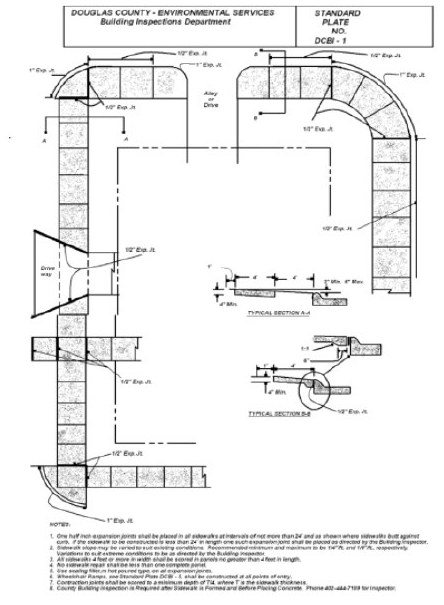
Section VI.9: Sidewalk Specifications
- A.All sidewalks in subdivisions with improved streets shall have their edge a minimum of six and one-half (6.5) feet from the backside of the curb. The intent of the setback from the curb is to allow for snow accumulation from plowing on the street and proper construction of ADA Accessible curb ramps. As approved by the County, it is acceptable to adjust the sidewalk spacing from the curb in order to preserve trees or to accommodate low impact development stormwater Best Management Practices.
- B.All sidewalks must be five (5) feet wide (minimum) and four (4) nominal inches thick (minimum) except at driveways, where walk is to be at least six (6) nominal inches thick. Sidewalks designed to be a part of an internal trail system and/or a part of the metropolitan area trail system shall meet the requirements of that trail which are generally eight (8) or ten (10) feet in width.
- C.All sidewalks must be constructed of Portland cement concrete and meet City of Omaha Standard Specification, current edition.
- D.All grades will be such as to match the adjoining existing curbs, sidewalks or drives in each individual construction area or as set by the County Engineer if above stated improvements do not exist.
- E.All sidewalks must have a cross slope of 1.5% but shall not exceed 2% in any case, and the slope shall be in conformance with any stormwater Best Management Practices installed along the sidewalk. The cross slope shall be held thru any driveway crossing and shall not be changed to match that in the driveway.
- F.Sidewalks adjacent to Lots shall be constructed with improvement to those lots but in no case shall that be more than 7 years from the final plat approval. Sidewalks adjacent to outlots or around the exterior of the subdivision shall be constructed by the applicant with the interior improvements.
- G.Construction of trails shall be as noted in the Subdivision Agreement.
Section VI.10: Landscape Guidelines for Tree Preservation
- A.Plan to provide for protection of 75% of existing tree canopy on the property.
- 1.For the purposes of these regulations, a “tree” is defined as a plant having at least one well-defined stem or trunk and normally attaining a mature height of at least 15 feet with an average mature spread of 15 feet.
- a.“Tree” definition taken from APA PAS Report # 491/492. A Glossary of Zoning, Development, and Planning Terms.
- 2.Tree canopy is estimated in square feet and this estimate should be indicated on the tree preservation plan submittal.
- 3.Applicant may request mitigation in lieu of maintaining the full 75% of existing tree canopy on the property. Mitigation ratio is 2:1. Tree replacement factor will be 500 square feet per tree.
- a.Example: If the area requiring mitigation is 2874 square feet, applying the 2:1 mitigation ratio means the applicant would be required to provide a new tree canopy area of 5748 square feet, (2874 square feet × 2) Dividing the 5748 by the tree replacement factor of 500 square feet per tree equals 11.5 trees. In this case, rounding up to 12 trees.
- 1.For the purposes of these regulations, a “tree” is defined as a plant having at least one well-defined stem or trunk and normally attaining a mature height of at least 15 feet with an average mature spread of 15 feet.
Section VI.11: Security
The applicant may select any method or combination of methods listed below to comply with required improvements:
- A.The applicant may post a performance bond or escrow account in the amount of 125% of the cost of the required improvements as estimated by a Professional Engineer hired by the applicant and licensed in the State of Nebraska and guaranteeing the installation of the improvements within 2 years after the plat has been recorded. The bond or escrow shall be released upon installation of the required improvements and certification by a Professional Engineer hired by the applicant and licensed in the State of Nebraska that all required improvements have been installed and confirmed by the County Engineer. Further, such period may be extended by the Board upon a showing by the applicant that lot sales and development does not warrant such installation. If the improvements are not completed within the specified or extended period of time, the performance bond shall be forfeited and used by the County to complete the installation of the improvements.
- B.A road improvement district or sanitary and improvement district (S.I.D.) may be created in accordance with appropriate State laws. Certified evidence shall be presented to the Board by the applicant that the improvement district has adopted a resolution of necessity and authorized a contract for the required work included in the final plat.
Section VI.12: Waivers
- A.A waiver of specific requirements of the subdivision regulations, can be requested by the Applicant. The Applicant must show in the case of the proposed subdivision, that compliance with the requirements of these regulations would result in hardship (as defined by state law). The Board upon recommendation from the Planning Commission, may vary, modify or waive requirements subject to determining that at a minimum the items below be considered:
- 1.The strict application of the zoning regulation would produce undue hardship.
- 2.Such hardship is not shared generally by other properties in the same zoning district and the same vicinity.
- 3.The granting of such variance is based upon reasons of demonstrable and exceptional hardship as distinguished from variations of the regulations for the purpose of convenience, profit or caprice.
- B.The waiver will not have the effect of nullifying the intent and purpose of these regulations or of the Comprehensive Plan.
Section VI.13: Phasing of Development
- A.If the Board approves a final plat for a portion of the area comprising the preliminary plat, the applicant may submit for final platting the next portion only if the required improvements have been installed or have been contracted to be installed. Subsequent applications for final platting shall be processed in the same manner.
Article VII: Administration and Enforcement
Section VII.1: Enforcement and Penalty
- A.No plat of any subdivision within the application of this regulation shall be entitled to be filed or recorded in the office of the Register of Deeds or have any validity until such plat has been prepared, approved and acknowledged in the manner prescribed by this regulation.
- B.It shall be unlawful to sell, trade or otherwise convey any lot or parcel of land as a part of or in conformity with any plan, plat or replat of any subdivision within the application of regulation unless said plan, plat or replat shall have first been approved as prescribed by this regulation and filed and recorded in the office of the Register of Deeds.
- C.No permit for building shall be issued for any structure on a site or parcel which is not a lot of record at the time of the effective date of this regulation or which has not been approved or recorded in accordance with the provisions of this regulation.
- D.No building permit will be issued for any lot within a subdivision until the dedicated public road improvements servicing that lot are in place and accepted by the County Engineer. Provisions for potable water, sanitary sewer and all other utilities, and stormwater best management practices must be finalized before issuance of any building permits. Certificates of occupancy will not be issued until all said water, sanitary sewer, other utilities, and stormwater best management practices are installed and functional for that lot.
- E.The penalty for violation of any provision of this regulation shall be a misdemeanor as provided for in Nebraska Revised Statutes §23-114.05.
Section VII.2: Appeals of Planning and Zoning Staff Interpretation of Definitions
The Planning and Zoning Coordinator or designee shall interpret all subdivision regulations and their application in this regulation. Appeals of those determinations may be submitted to the Board of Adjustment as provided for under N.R.S. §23.168.02 for consideration.
Section VII.3: Filing Fees
Refer to general fee schedule for preliminary and final plat filing fees.
Section VII.4: Minor Survey or Drafting Errors
Minor survey or drafting errors in a recorded plat shall meet the requirements of the County Engineer’s Office and the County Register of Deeds Office.
Appendix A – Signature Blocks and Certifications
Owners Certification
I/We the undersigned owner(s) of the real estate shown and (names) described herein, do hereby certify that I/we have laid out, platted and subdivided, and do hereby lay out, plat and subdivided, said real estate in accordance with this plat.
This subdivision shall be known and designated as . All streets and alleys shown and not heretofore dedicated are hereby dedicated to the public unless specifically noted herein. Other public lands shown and not heretofore dedicated are hereby reserved for public use.
There are strips of ground 5 feet in width along all front and side boundary lot lines, 8 feet wide along all rear interior lot lines and 16 feet wide along all exterior rear lot lines, or as shown on this plat and marked permanent easement, reserved for the use of public and private utilities and subject to the paramount right of utility or City to install, repair, replace and maintain its installations. No permanent buildings, trees, retaining walls or loose rock walls shall be placed in said easement but the easement may be used for gardens, shrubs, landscaping sidewalks, driveways or other purposes that do not then or later interfere with aforesaid uses or rights.
(Additional covenants or restrictions and enforcement provisions therein may be inserted here or attached to the plat).
Witness our Hands and this day of , 20.
Notary for Each Owner
STATE OF NEBRASKA
COUNTY OF DOUGLAS
Before me, the undersigned Notary Public, in and for the County and State, personally appeared and each separately and severally acknowledge the execution of the foregoing instrument as his or her voluntary act and deed, for the purposes therein expressed.
Witness my Hand and Notarial Seal this day of , 20__
Surveyors Certification
I, hereby certify that I am a professional land surveyor, registered in compliance with the laws of the State of Nebraska, that this plat correctly represents a survey conducted by me or under my direct supervision on , that any changes from the description appearing in the last record transfer of the land contained in the final plat are so indicated, that all monuments shown thereon actually exist as described or will be installed and their position is correctly shown and that all dimensional and geodetic data is correct.
Administrative Plat
This administrative plat of has been submitted to and approved by the Douglas County Planning office this day of , 20.
County Planning Commission
This plat of has been submitted to and approved by the Douglas County Planning Commission this day of , 20.
County Board
This plat of was approved by the County Board for Douglas County, Nebraska this day of , 20__.
ATTEST:
County Register of Deeds
The appropriate space shall be reserved at the top of the plat per Douglas County Register of Deeds current standards for recording of the plat.
County Treasurer’s Certifications
This is to certify that I find no regular or special taxes due or delinquent against the property described in the Surveyor’s Certificate and embraced in this plat as shown by the records of this office this day of , 20.
Review of County Engineer/Surveyor
This plat of was reviewed by the office of Douglas County Engineer/Surveyor on this day of , 20.
Appendix B – Roadway Design Standards Table
| Classification | Location or Type | Design Year ADT | ROW width (ft) | Design Speed (mph) | Pavement Width ᵈ (ft) | Shoulder Width (ft) | Surfacing Type |
|---|---|---|---|---|---|---|---|
| Arterial Street | Exterior (all section line roads) | 2,000+ | ᵃ 120 | 55 | 48 | 8 | Paved |
| Under 2,000 | ᵃ 120 | 50 | 24 | 6 | Paved | ||
| Interior | 2,000+ | ᵃ 120 | 45 | 68 | N/A | Concrete w/ curb & gutter | |
| Under 2,000 | ᵃ 120 | 45 | 38 | N/A | Concrete w/ curb & gutter | ||
| Frontage Road | Interior | All | 40 | 30 | ᶜ 25 | N/A | Concrete w/ curb & gutter |
| Collector Streets | Exterior | 2,000+ | ᵃ ᵇ 100 | 55 | 36 | 8 | Paved |
| Under 2,000 | ᵃ ᵇ 100 | 50 | 24 | 6 | Paved | ||
| Interior | 400+ | ᵃ ᵇ 80 | 30 | 38 | N/A | Concrete w/ curb & gutter | |
| Under 400 | ᵃ ᵇ 80 | 30 | 38 | N/A | Concrete w/ curb & gutter | ||
| Local Street | Exterior | 2,000+ | ᵇ 100 | 55 | 36 | 8 | Paved |
| Under 1,999 | ᵇ 100 | 50 | 24 | 6 | Paved | ||
| Interior | 400+ | ᵇ 60 | 25 | 25 | N/A | Concrete w/ curb & gutter | |
| Under 400 | ᵇ 60 | 25 | 25 | N/A | Concrete w/ curb & gutter | ||
| Alleys | Residential | All | 20 | 15 | 12 | 4 | Paved |
| Commercial / Industrial | All | 20 | 15 | 20 | 0 | Paved | |
| Cul-de-sac Streets | Interior (road) | 200 and under | ᵇ 60 | 25 | 25 | N/A | Concrete w/ curb & gutter |
| Interior (circle) | 200 and under | ᵇ 125 | 25 | ᵉ 100 | N/A | Concrete w/ curb & gutter |
Notes
- a.streets in these classifications shall be designed and graded to the full right-of-way widths stated
- b.collector and/or lessor volume streets may be narrowed in width if such narrowing is designed to reduce overall impervious surfaces pursuant to the subdivision’s overall stormwater management. Such width adjustments shall not cause to impede the provision of essential services
- c.sidewalks will only be required on one side (away from arterial street or highway).
- d.pavement width provided is for a street with no parking. If parking on one side of the street is requested, add a minimum of 4 feet to the total width, for parking on both sides of the street add 9 feet to the total width. Parking will not be allowed on Arterial Street or Alleys and only with approval on Collector Street.
- e.the diameter or radius of the end of the cul-de-sac may be adjusted with approval or at the request of the local fire department to meet their equipment needs.