

8.01 Purpose
Overlay Districts are used in combination with Base Districts to modify or expand base district regulations. They adapt to the special needs of areas of the County and further allow this regulation to evolve as the planning and development needs and trends of specific areas also change. The Overlay Districts are designed to achieve the following objectives:
- A.
To recognize special conditions in specific parts of the County which require specific regulation.
- B.
To provide for the protection of special features in the natural and built environment.
- C.
To allow for change and adaptability to different needs and trends in land development.
- D.
To encourage comprehensive development and environmental planning.
- E.
To provide flexibility in development and to encourage innovative design through comprehensively planned projects.
8.02 Establishment of Districts
The following Overlay Districts are hereby established.OVERLAY DISTRICTS
- PD
- Planned Development District
- HCG
- Highway Corridor Gateway Overlay District
- FP/FW
- Floodplain/Floodway Overlay District
8.03 PD – Planned Development Overlay District
- A.
Purpose
The PD Planned Development Overlay District is intended to provide flexibility in the design of projects; to encourage innovation in project design that incorporates open space and other amenities; and to ensure compatibility of developments with the surrounding environment. The PD Planned Development District is intended to promote developments which will be advantageous to the County and its form by permitting project design that will surpass the quality of development resulting from application of the regulations of conventional zoning districts.
While the PD District may appear to deviate from a literal interpretation of the land development regulations, it is not intended to encourage deviations from the County’s comprehensive plan or overall development objectives. The District shall not be used to secure approval for projects that do not conform to the County’s comprehensive plan.
- B.
Criteria for Use
The PD Planned Development District is generally intended for use in the following contexts.
- 1.
Vacant Land. Areas of vacant land where the structure of conventional zoning may artificially limit or constrain good urban design, may restrict the achievement of the County’s development objectives, or may not be appropriate to changes in technology or demand consistent with the best interests of the County.
- 2.
Neighborhood Contexts. Areas in which sensitive project design is critical to maintain and protect the value of surrounding residential neighborhoods and other sensitive or vulnerable settings.
- 3.
Large Projects. Projects which have substantial effects on their surroundings because of their size and scale.
- 4.
Large areas that may be zoned, consistent with the Comprehensive Plan, prior to development, but that require individual project approval as development occurs.
- 1.
- C.
Permitted Land Uses
A Planned Development may include residential, office, commercial, industrial, or public land uses, subject to finding of conformance with the comprehensive plan.
- D.
The PD District: Application Procedures:
- 1.
Minimum Size: The minimum size of a PD District shall be three acres.
- 2.
Pre-application Concept Plan: Prior to filing an application for approval of a PD District, the applicant shall meet with the Zoning Coordinator for the purpose of submitting a pre-application concept plan. This plan shall illustrate the conceptual overall plan for the District and shall include at a minimum the information required in Table 8.1: PD Planned Development District Application Requirements.
- 3.
The Zoning Coordinator shall provide the applicant with written comments within thirty days of the concept plan meeting.
- 4.
The review of the concept plan shall include consideration of the following criteria:
- a.
Land use intensity and density.
- b.
Ability to provide a positive environment for intended uses, including schematic building configurations, arrangements, and general landscaping and site design.
- c.
Use of open space.
- d.
Impact on the surrounding natural and built environment.
- e.
Adequacy of on- and off-site transportation and utility systems to serve the proposed project.
- f.
Consistency with the comprehensive plan.
- a.
- 5.
Following receipt of the Zoning Coordinator’s comments, and revisions made, the applicant may proceed with filing a formal application for approval of a PD District. This shall illustrate the development plan for the District and shall include at a minimum the information required in Table 8.1.
- 6.
A PD application shall include a Development Agreement establishing the development regulations for the district. The Development Agreement shall specify the following:
- a.
Location and quantities of various land uses.
- b.
Maximum residential densities.
- c.
Maximum building and impervious coverage.
- d.
Front, side, and rear yard setbacks.
- e.
Maximum heights of proposed structures.
- f.
Design standards applicable to the project.
- g.
Incorporation of graphic development plans and drawings into the site development regulations.
- a.
- 7.
The Planning Commission and County Board shall review and evaluate each PD District application following procedures as for a zoning amendment. The Planning Commission and County Board may impose reasonable conditions, as deemed necessary to ensure that a PD District shall be compatible with adjacent land uses, will not overburden public services and facilities and will not be detrimental to public health, safety and welfare. The Planning Commission and County Board shall base decisions on findings of fact as set forth in the criteria presented in Table 8.2.
- 8.
Issuance of Building Permits: The County shall not issue a building permit, certificate of occupancy, or other permit for a building, structure, or use within a PD District unless it is in compliance with the approved Development and Amendment and Concept Plan.
- 9.
Changes or Modifications to Development Plans. The Zoning Coordinator is authorized to approve amendments to an approved development plan provided that:
- a.
A written request is filed with the Zoning Coordinator, along with information specifying the exact nature of the proposed amendment.
- b.
The amendment is consistent with the provisions of this article.
- c.
The amendment does not alter the approved site regulations of the development plan and does not materially alter other aspects of the plan, including traffic circulation, land uses or land use intensity, mixture of use types, and physical design.
- d.
Any amendment not conforming to these provisions shall be considered equivalent to a new application and shall be submitted according to the procedures for new applications established in this section.
- a.
- 10.
Termination of PD District: If no substantial development has taken place in a PD District for three years following approval of the District, the Planning Commission and County Board may reconsider the zoning of the property and may, on its own motion, initiate an application for rezoning the property.
TABLE 8.1 – PD PLANNED DEVELOPMENT DISTRICT APPLICATION REQUIREMENTS Application Requirement PD Concept Plan PD Application Location, size, legal description of site X Existing topography at 2-foot intervals X Location and description of major site features, including tree masses, water areas or drainage ways, wetlands, soils, native prairie, floodplains. X A map showing land uses within 200 feet of the boundary of the site X Location of 100-Year Floodplains X Generalized land use plan. X Proposed types and densities of development. X Generalized internal and external transportation and circulation system, including pedestrian and bicycle system. X General location and size of buildings or building footprints. X Statistical summary of the project, including gross and net site area, number of housing units by type, gross floor area of other uses, total amount of parking, and building and impervious surface coverage. X X Site master plan, including general envelopes of buildings, parking, open space, and other site features. X Description and location of all use types included in the project, including maximum floor areas devoted to each use. X Location and design of vehicular, bicycle, and pedestrian circulation systems, including relationship to external transportation system. X Schematic location and development standards for open space, including conceptual landscape plan. X Grading plan at 1-foot contours, including erosion control plans. X Building design standards, including height, materials, sections, and other information required to describe the project. X Location of existing and proposed utilities, sanitary sewers, storm water facilities, and water, gas, phone, cable, and electrical distribution systems. X X General locations and sizes of signs and street graphics. X Location of driveways or access points adjacent to the project. X Proposed site development regulations, or other density regulators, building and impervious coverage, setbacks, maximum heights, and other design standards specific to the project. X Detailed site plan, displaying specific location or building envelope limits for all major site structures; location of open spaces; parking facilities; and vehicular circulation. X Exterior building elevations and floor plans. X Detailed open space and landscape plan. X Utility plans for all proposed utility improvements. X Location, size, style, and lighting of signage, including directional and signage control. X Location and design of proposed site lighting. X Proposed public and private ownership boundaries, including proposed private lots and common ownership areas. X Preliminary plat if applicable. X Final plat if applicable. Schedule indicating proposed phasing and scheduling of development. X Deed restrictions, covenants, agreements, association bylaws, and other documents controlling the use of property, type of construction, or development or activities of future residents. If required. Appropriate bonds to ensure construction of public improvements. X
- 1.
General Notes:
- 1.
All items required for submittal of concept plan shall be a part of the application for approval of the PD District.
- 2.
Plans submitted in support of an application shall be as required by the Zoning Coordinator.
TABLE 8.2 – REVIEW CRITERIA AND STANDARDS FOR FINDING OF FACT Criteria for Findings of Fact Land Use Compatibility Density Applies to PD Development Density Should be similar to surrounding uses if not separated by major natural or artificial features. X Height and Bulk Development should minimize differences in height and building size from surrounding structures. Differences should be justified by design considerations. X Setbacks Development should respect pre-existing setbacks. Variations should be justified by site or operating characteristics. X Building Coverage Building coverage should be similar to that of surrounding development. Higher coverage should be mitigated by landscaping or site amenities. X Site Development Environment Compliance with conservation design criteria per this regulation and the Comprehensive Plan. X Parking and Internal Circulation Parking should serve all structures with minimal conflicts between pedestrians and vehicles. X All structures must be accessible to public safety vehicles. X Development must have access to adjacent public streets and ways. Internal circulation should minimize conflicts and congestion at public access points. X Open Space Open spaces should contribute to the quality of the overall project and should provide supporting amenities for the development. Open spaces should contribute to the design of the project and, when appropriate, provide locations for project-related activities. X Landscaping Landscaping should be integral to the development, providing street landscaping, breaks in uninterrupted paved areas, and buffering where required by surrounding land uses. Project design must preserve features of environmental importance, consistent with Article 7 Conservation Design regulations X Streetscape Projects should relate to surrounding public streets and contribute to the quality of the street environment. X Architectural Quality Architectural design and building materials should be compatible with surrounding areas or reflect the specific design objectives of a new development area. Traffic Capacity Project should not reduce the existing level of traffic service on adjacent streets. Compensating improvements should be included to mitigate impact on street system operations. X Street Network and Continuity Project should maintain the continuity of the County’s street network or should provide opportunities for local traffic flow away from major arterials. X Alternative Modes Project should make appropriate accommodations for access by public transportation, bicycles, and pedestrians. X Utility Service Project is adequately served by public utilities and infrastructure. X Storm Drainage Project should handle storm water appropriately and consistent with the Comprehensive Plan. Project should not inhibit development of other properties or create adverse effects on other sites. Development should not increase probability of erosion, flooding, landslides, or other run-off related effects. Project should incorporate Best Management Practices (BMP), including but not limited to, Low Impact Development (LID) techniques and maximize preservation and enhancement of natural drainage features on site and should facilitate storm water storage techniques consistent with the policies of the County. X Public Safety Project can be adequately served with police and fire protection. X Consistency with Comprehensive Development Plan Objectives Project must be consistent with the comprehensive plan, including applicable special area or specific plans. Project design should be consistent with the development standards and objectives of these plans. X
8.04 HCG – Highway Corridor Gateway Overlay District
- A.
Purpose
The HCG Highway Corridor Gateway Overlay District provides basic guidelines that promote quality design along the most visible and heavily traveled road corridors in the Douglas County‘s zoning jurisdiction. The HCG District is intended to:
- 1.
Encourage development design that strengthens the physical character and image of the County.
- 2.
Supports the value of property and quality of development and major highway corridors.
- 3.
Set basic requirements for good site design and development, building design, landscaping, and signage without discouraging creativity and flexibility in design.
- 4.
Permit safe and convenient transportation access and circulation for motorized and non-motorized vehicles, and for pedestrians.
- 5.
Manage the impact of commercial and industrial development on adjacent residential neighborhoods.
- 1.
- B.
HCG Highway Corridor Gateway Overlay District Boundaries
The HCG District applies to the following areas:
- 1.
Land within one-quarter [¼] mile of the centerline of Highway 36 within the County’s planning jurisdiction; and
- 2.
Land within one-quarter [¼] mile of the centerline of Highway 92 within the County’s planning jurisdiction
- 1.
- C.
Project Application and Exceptions
The HCG Overlay District applies to the following:
- 1.
Any new improvement requiring a building or development permit built on any land within the boundaries of the HCG Overlay District after the effective date of this District.
- 2.
The requirements of the HCG Overlay District do not apply to any rehabilitation, repair, addition(s) or enlargement(s) of a building in place or under construction on a site as of the effective date of this regulation, provided that the cumulative gross floor area of any addition(s) does not exceed 50% of the gross floor area of the pre-existing building(s).
- 1.
- D.
Design Guidelines for Commercial and Office Uses
- 1.
Site Design Guidelines
- a.
Relationship to Landforms
- i.
Buildings shall maintain a minimum buffer of 100 feet from the edge of any wetlands identified by the National Wetlands Inventory or a site specific inventory of wetlands.
- ii.
Site design shall minimize cut-and-fill and, to the maximum degree possible, follow the natural topography of the site.
- iii.
Developments shall follow conservation development standards as listed in this regulation as relates to the preservation of natural features. Developments that remove trees shall replace them according to the following schedule. All replacement trees must follow the Nebraska State Arboretum’s list of recommended species and shall be subject to County approval.
Tree Replacement Schedule
Caliper measurement of removed tree Required number of replacement trees for each removed tree 3 inches or less 1 tree 3.1 to 6 inches 2 trees 6.1 to 9 inches 3 trees Over 9 inches 4 trees
- i.
- b.
Building Location and Orientation
Facades with principal entrances shall be oriented to the project’s primary street or to an active pedestrian or public zone within the site. For multi-tenant buildings, at least 50% of the entrances shall be oriented to the primary street or pedestrian or public zone. Facades with principal customer entrances may be turned perpendicular to the primary street if they provide a direct pedestrian connection from a public sidewalk to the major customer entrance without interruption by vehicular traffic. When the development has two primary streets, the site plan shall determine orientation.
- i.
Developments should maximize the amount of parking located in the side or rear of buildings and should locate buildings near their primary fronting streets. Parking exposure to Highway 36 and Highway 92 shall be minimized.
- ii.
Developments at intersections shall identify or emphasize their corners with significant landscaping or similar public feature.
- iii.
A clearly delineated pathway or route shall connect all principal building or business entrances to any sidewalks or trails on streets adjacent to the project.
- i.
- c.
Pedestrian Access
- i.
Developments shall provide a continuous walkway connection at least 5 feet in width from the public sidewalk or right-of-way to the customer entrances of all principal buildings on the site. Developments adjacent to multi-use trails shall provide a direct connection from the trail to the development’s internal pedestrian circulation system. For trails that are proposed in the comprehensive plan, trail master plan, or other adopted county document but are not yet constructed, the development plan shall make provisions for a connection to the trail, and shall be responsible for constructing the connection when the trail becomes available.
- ii.
Multi-building developments shall provide clear and safe walkways at least 5 feet in width that connect all buildings on the site. Buildings not intended for routine customer access or intended solely for drive-up services are excluded from this requirement.
- iii.
Where the required walkways specified in this article cross drives, parking aisles, or other vehicular ways, the crosswalks shall be distinguished from driving surfaces by the use of durable, low-maintenance surface materials such as concrete or brick pavers; or scored, colored concrete. Painted concrete is not acceptable in this application.
- iv.
In parking lots with over 200 stalls, the required walkways specified in this section shall be located in landscaped medians or corridors that include trees and groundcovers for at least 50% of their combined length.
- v.
Sidewalks no less than 5 feet in width and separated by curbs from adjacent vehicular circulation ways shall be provided along the full length of the building along any façade that either includes a customer entrance or adjoins a customer parking area.
- vi.
Pedestrian connections to adjacent developments shall be provided. If adjacent properties are undeveloped, the development plan shall indicate how future connections will be provided.
- i.
- d.
Vehicular Access
- i.
Development plans shall minimize the number of access points to the highway corridors. Access from arterial streets shall be controlled by the Douglas County Engineer and the Nebraska Department Roads, as applicable. Developments shall make maximum use of internal cross-easements and shared access points when possible. Cross accesses between adjacent properties shall use traffic calming techniques to reduce speeds.
- ii.
Main driveways and drive aisles shall provide a continuous system that connects to the main site entrance.
- iii.
Commercial developments are encouraged to provide means of access to residential areas that avoid requiring residents to use arterial streets for short-distance trips. Such connections must be designed to avoid channeling commercial traffic onto residential streets outside of comprehensively planned, mixed use projects.
- iv.
When possible, shared service and delivery access should be provided between adjacent parcels and buildings.
- i.
- e.
Parking
- i.
Parking shall be grouped into parking blocks that are defined by pedestrian paths, landscaping, and buildings.
- ii.
A maximum of 400 parking stalls may be located in any one parking block.
- i.
- f.
Signs
Attached signs shall be designed as an integral part of the building elevation and integrated into the overall design of the building. Attached signs shall be located above the building entrance, storefront opening, or at other locations that are consistent with and emphasize the architectural features of a building.
- i.
All new commercial or office development shall use monument or ground signs no more than 8 feet in height.
- ii.
A landscaped base area shall be provided for monument or ground signs appropriate to the mass and height of the sign. As a guideline, a base area of 1.5 square feet shall be provided (with a minimum of 5’ from the base of the sign) for each square foot of sign area. The landscaped area may include trees, shrubs, flowering perennials, ornamental tall grass, fountains, water features, decorative stonework, planters, sculpture, and decorative paving (as approved by the Zoning Coordinator in writing). Loose stone or mulch alone are not credited for satisfying this requirement. Irrigated turf grass is discouraged. Native and sustainable plant materials are encouraged.
- iii.
Other sign regulations and requirements are set forth in this regulation.
- i.
- g.
Screening
- i.
Developments shall provide year-round screening of loading docks, truck parking, outdoor storage, utility meters, HVAC equipment, trash collection and processing, and other service functions. Screening shall be provided for 75% of the vertical plane of these features, up to a height of eight feet. Trash enclosure gates shall furnish a steel frame with decorative steel or wood covering, or another design acceptable to the Zoning Coordinator. Chain-link fencing with inlaid wood or metal slats shall not be considered acceptable. Screening shall be integrated into the overall design of buildings and landscaping and fully contain the visual impact of these service functions from adjacent public streets and neighboring properties.
- ii.
Architectural elements, materials, colors, and design of screening walls, coverings, and fences shall be consistent with the predominant materials, colors, and elements of the primary building.
- i.
- h.
Lighting
- i.
All lighting used to illuminate an off-street parking area, sign or other structure shall be arranged so as to deflect light away from any adjoining property and from public streets through fixture type and location (i.e., there shall be no light trespass). When lighting is mounted to the underside of canopies, these lights shall be recessed so that the visible light source is no lower than the plane of the underside of the canopy.
- ii.
The maximum height of lighting standards shall be 35 feet, unless the County grants a specific exception as part of the application approval process.
- iii.
Exterior lighting of buildings shall be limited to low-level incandescent spotlights, floodlights, and similar illuminating devices hooded in such a manner that the direct beam of any light sources will not glare upon adjacent property or public streets. The County may approve exceptions to these requirements for sports and athletic field lighting, flagpole lighting, public street lighting, temporary lighting for seasonal/holiday or special events, and lighting used for public safety.
- a.
- 2.
Architectural Guidelines
- a.
Mass and Scale for Buildings
- i.
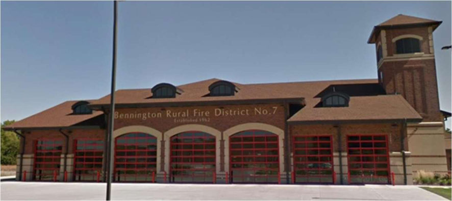
Variations in the vertical plane of a building shall be incorporated into the mass if the building at significant entrances or along walls that front plazas or other significant pedestrian features. Methods of breaks may include towers, pediments, or façade articulations or variations; changes in the horizontal plane; or enhancements in color and materials, consistent with the overall design of the building.
- ii.
Primary building facades shall meet one of the following guidelines:
- i.
- a.
- 1.
Facades greater than 100 feet shall incorporate projections or recesses in the wall plane with a depth of at least 3% of the length of the façade and extending for at least 20% of the length of the façade. Maximum uninterrupted length of wall shall be 100 feet.
- 2.
Facades shall display a repeating pattern of at least three cycles of color change, texture change, material change, or expression of structural bays with an offset of at least 12 inches from the ruling plane of the façade.
- 3.
The Zoning Coordinator may waive these guidelines if the applicant demonstrates an alternative building design that provides visual interest and scale to the building.
- 4.
Mass and Scale for Buildings over Two Stories
Building mass and architectural elements shall differentiate between the first floor of the building and upper levels of the façade.
- 5.
Architectural Elements
- a.
Front facades facing a primary street shall have visible, clearly defined customer entrances that include at least three of the following elements: canopies or porticos, overhangs, recesses or projections, arcades, raised cornice parapets over the entrance door, distinctive roof forms, arches, outdoor patios or plazas, display windows, or integral planters.
- b.
At least 20% of the surface area of front commercial facades up to a height of 16 feet shall be transparent.
- c.
Front facades shall utilize variations in color, horizontal planes, materials, patterns, height, and other techniques to provide visual interest and scale to buildings.
- d.
All rear and side building facades oriented to arterial or collector streets shall be subject to all requirements for front façade design with the exception of providing customer entrances.
- e.
Other rear and side facades may use a simplified expression of the materials and design used on other building elevations.
- a.
- 6.
Building Materials
- a.
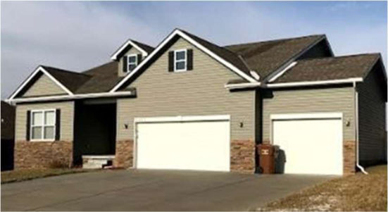
Permitted exterior building materials shall be high quality, durable materials that include, but are not limited to, brick; native or manufactured stone (renaissance masonry or similar masonry materials); integrally colored, burnished, textured, or glazed concrete masonry units; pre- finished architectural metal panel systems; quality metals such as copper; high quality pre- stressed concrete systems; and drainable (water managed) Exterior Insulated Form System (EIFS).
- b.
The following exterior materials are prohibited: split shakes, rough-sawn wood; painted concrete block; tilt-up concrete panels without an architectural finish; field-painted or pre- finished standard corrugated metal siding; standard single- or double-tee concrete systems; or barrier type EIFS.
- c.
Materials on all sides of the building shall be consistent with materials on the front façade.
- d.
These guidelines are not intended to inhibit creativity and innovation in building design. The Zoning Coordinator may permit the use of other materials if the applicant demonstrates that the use of such materials will result in a building that gives a sense of quality and permanence.
- a.
- 7.
Roof Forms
- a.
Buildings with flat or slightly sloped roofs to drain shall incorporate parapets on all facades that face a public street or residential district. Variations in parapet height and articulation of cornice lines may be used to add interest.
- b.
Roof forms shall be designed to express various building functions and features, such as entrances.
- c.
Visible roof materials shall include clay or concrete tile, tern metal, architectural grade asphalt shingles, architectural metals, copper, natural or synthetic slate, or similar durable materials.
- d.
Mansard or false roofs shall be prohibited.
- e.
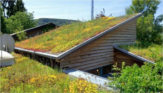
Green roofs, as a storm water BMP and consistent with industry standards, are encouraged to be utilized in combination with other storm water BMPs.
- a.
- 1.
- E.
Design Guidelines for Industrial Uses
These guidelines apply to industrial development within the HCG Overlay District.
- 1.
Site Design Guidelines
- a.
Relationship to Landforms
- i.
Buildings shall maintain a minimum buffer of 30 feet from the edge of any Special Flood Hazard Area on the most current Flood Insurance Rate Maps or from the edge of any wetlands identified by the National Wetlands Inventory or a site specific inventory of wetlands.
- ii.
Site design shall minimize cut-and-fill and, to the maximum degree possible, follow the natural topography of the site.
- iii.
Developments shall preserve natural and scenic areas, streams and natural drainage ways, floodplains, prairies, and wetlands.
Developments shall, to the maximum degree possible, preserve individual trees or stands of trees. Developments that remove trees shall replace them according to the following schedule. All replacement trees must follow the Nebraska State Arboretum’s list of recommended species and shall have a caliper of at least 2 inches.
Tree Replacement Schedule
Caliper measurement of removed tree Required number of replacement trees for each removed tree 3 inches or less 1 tree 3.1 to 6 inches 2 trees 6.1 to 9 inches 3 trees Over 9 inches 4 trees
- i.
- a.
Building Location and Orientation
- i.
To the maximum degree possible, the arrangement of buildings on a site shall screen operational and loading areas from view from surrounding public streets.
- ii.
To the maximum degree possible, buildings should be clustered within a site.
- iii.
Buildings with customer entrances shall orient such entrances toward the primary access street. Service functions, including but not limited to loading docks, truck parking, outdoor storage, utility meters, HVAC equipment, trash collection and processing, and other service functions, shall be oriented away from primary access streets.
- iv.
Accessory structures shall not front a primary access street and shall be oriented away from public streets, open space, or residential areas. Such structures shall not be visible from primary corridor or highway.
- v.
Buildings shall be arranged and oriented so that loading docks, outdoor storage, trash collection and processing, HVAC equipment, truck parking and servicing areas, and other service functions are not visible from the primary corridor or highway. Site designs shall maximize the amount of landscaping in street yards along these highways. This standard may be met by building and site orientation, site design, and/or landscaped screening that blocks the view of such areas from the highway corridors. Customer and employee parking areas are permitted in these street yards, subject to other provisions of this regulation.
- i.
- b.
Pedestrian Access
- i.
Developments shall provide a continuous walkway connection at least 5 feet in width from the public sidewalk or right-of-way to the customer and/or office entrance of the development.
- ii.
Where the walkways required by this section cross driveways, parking aisles, or other vehicular ways, the crosswalks shall be distinguished from driving surfaces by the use of crosswalk striping, change in paving material, or other durable, low- maintenance surface techniques.
- i.
- c.
Vehicular Access
- i.
Development plans shall minimize the number of access points to the highway. Access from arterial streets shall be controlled by the Douglas County Engineer and the Nebraska Department Roads, as applicable. Developments shall make maximum use of internal cross-easements and shared access points when possible. Cross accesses between adjacent properties shall use traffic calming techniques to reduce speeds.
- ii.
To the maximum degree possible, access routes for automobiles and trucks shall be distinguished from one another.
- iii.
Drives and access points shall be directed away from residential areas.
- i.
- d.
Parking
- i.
Signage and site design shall distinguish employee and visitor parking areas from truck loading and servicing areas when the project is sufficiently large to make such separation functionally necessary.
- ii.
Landscaping shall be used to direct vehicles through the site, distinguish between automobile and truck service areas, manage storm water, and break up the size of large impervious parking and loading areas.
- i.
- e.
Signs
- i.
Attached signs shall be integrated into the design of the building elevation.
- ii.
All new industrial development shall use monument or ground signs, no more than 8’ in height.
- iii.
Other sign regulations and requirements are set forth in Article 11.
- i.
- f.
Screening
- i.
Developments shall provide year-round screening of loading docks, truck parking, outdoor storage, utility meters, HVAC equipment, trash collection and processing, and other service functions if these features are visible from adjacent public streets or neighboring residential properties. Screening shall be provided for 75% of the vertical plane of these features, up to a height of eight feet. Trash enclosure gates shall furnish a steel frame with decorative steel or wood covering, or another design acceptable to the Zoning Coordinator. Chain-link fencing with inlaid wood or metal slats shall not be considered acceptable. Screening shall be integrated into the overall design of buildings and landscaping and fully contain the visual impact of these service functions from adjacent public streets and neighboring properties.
- ii.
Architectural elements, materials, colors, and design of screening walls, coverings, and fences shall be consistent with the predominant materials, colors, and elements of the primary building.
- iii.
All rooftop mechanical equipment shall be screened. Acceptable methods of screening include parapet walls or a free-standing screen of a material and color consistent with the building. Screens shall be at least the same height as the equipment they conceal.
- iv.
Other screening requirements are set forth in Article 9, Landscaping Regulations.
- i.
- g.
Lighting
- i.
All lighting used to illuminate off-street parking areas, signs or other structures shall be arranged so as to deflect light away from any adjoining property and from public streets through fixture type and location. There shall be no light trespass.
- ii.
The maximum height of lighting standards shall be 35 feet, unless the County grants a specific exception as part of the application approval process.
- iii.
Exterior lighting of buildings shall be limited to low-level incandescent spotlights, floodlights, and similar illuminating devices hooded in such a manner that the direct beam of any light sources will not glare upon adjacent property or public streets. The County may approve exceptions to these requirements for sports and athletic field lighting, flagpole lighting, public street lighting, temporary lighting for seasonal/holiday or special events, and lighting used for public safety.
- i.
- a.
- 2.
Architectural Guidelines
- a.
Mass and Scale
- i.
For buildings with office areas that exceed 3,000 square feet, the mass of the office portion of a building shall be distinguished from the mass of the industrial operations portion of the building. Office and/or public entrances shall be distinguished by elements that provide both identification and scale to the development. Techniques include but are not limited to the use of canopies or porticos, overhangs, changes in horizontal plane, variations in façade height and design, arches, peaked or special roof forms, and changes in materials.
- ii.
At least 30% of the surface area of the office and customer- oriented portion of a building shall be of transparent materials.
- i.
- b.
Building Materials
- i.
Permitted exterior building materials on primary exposure facades shall be high quality, durable materials that include, but are not limited to, brick; native or manufactured stone (Renaissance stone or similar masonry materials); integrally colored, burnished textured, or glazed concrete masonry units; pre-finished metal panel systems; quality metals such as copper; high quality pre-stressed concrete systems; architecturally treated tilt-up concrete panels; and drainable (water managed) EIFS. Primary exposure facades shall include any façade that is oriented to a highway, and all building facades that intersect a façade oriented to these highway corridors for a distance of 200 feet back from such intersection; and any façade oriented to a public open space, or residential area.
- ii.
The following materials are prohibited on any development affected by these guidelines: split shakes, rough-sawn wood; field-painted standard corrugated metal siding; or barrier type EIFS.
- iii.
Smooth-faced concrete block, tilt-up concrete, pre-engineered metal buildings, and standard single- and double-tee concrete systems shall be permitted only on facades that are not primary exposure facades as defined above.
- iv.
These guidelines are not intended to inhibit creativity and innovation in building design. The Zoning Coordinator may permit the use of other materials if the applicant demonstrates that the use of such materials will result in a building that gives a sense of quality and permanence.
- i.
- c.
Roof Forms
- i.
Visible roof materials shall include clay or concrete tile, pre- finished metal, architectural grade asphalt shingles, architectural metals, copper, natural or synthetic slate, or similar durable materials. Membrane roof systems are prohibited on any routinely visible portion of the roof.
- ii.
Mansard or false roofs shall not be used.
- i.
- a.
- 1.
- F.
Design Guidelines for Multi-Family Uses
These guidelines apply to multi-family development within the HCG Overlay District.
- 1.
Site Design Guidelines
- a.
Relationship to Landforms
- i.
Buildings shall maintain a minimum buffer of 30 feet from the edge of any Special Flood Hazard Area on the most current Flood Insurance Rate Maps or from the edge of any wetlands identified by the National Wetlands Inventory or a site specific inventory of wetlands.
- ii.
Site design shall minimize cut-and-fill and, to the maximum degree possible, follow the natural topography of the site.
Tree Replacement Schedule
Caliper measurement of removed tree Required number of replacement trees for each removed tree 3 inches or less 1 tree 3.1 to 6 inches 2 trees 6.1 to 9 inches 3 trees Over 9 inches 4 trees - i.
- b.
Building Location and Orientation
- i.
Buildings shall be grouped in ways that avoid continuous rows of building walls and permit visibility into the development from surrounding streets.
- ii.
Building siting shall define open spaces. Building entrances shall be oriented toward and provide direct entrances to major open spaces.
- iii.
Typically, buildings that are directly adjacent to single-family residential development shall minimize the mass of buildings that directly face single-family structures. Where parallel orientation is necessary, setbacks from the street shall be greater than the required minimum setbacks and buildings shall include design and elevation features that complement adjacent lower-density development.
- i.
- c.
Pedestrian Access
- i.
Developments shall provide a continuous walkway connection at least 5 feet in width from the public sidewalk or right-of-way to the customer entrances of all principal buildings on the site. Developments adjacent to multi-use trails shall provide a direct connection from the trail to the development’s internal pedestrian circulation system. For trails that are proposed in the comprehensive plan, trail master plan, or other adopted county document but are not yet constructed, the development plan shall make provisions for a connection to the trail, and shall be responsible for constructing the connection when the trail becomes available.
- ii.
Multi-building developments shall provide clear and safe walkways at least 5 feet in width that connect all buildings on the site. Buildings not intended for routine customer access or intended solely for drive-up services are excluded from this requirement.
- iii.
Where the required walkways specified in this article cross drives, parking aisles, or other vehicular ways, the crosswalks shall be distinguished from driving surfaces by the use of durable, low-maintenance surface materials such as concrete or brick pavers; or scored, colored concrete. Painted concrete is not acceptable in this application.
- iv.
In parking lots with over 200 stalls, the required walkways specified in this section shall be located in landscaped medians or corridors that include trees and groundcovers for at least 50% of their combined length.
- v.
Sidewalks no less than 5 feet in width and separated by curbs from adjacent vehicular circulation ways shall be provided along the full length of the building along any façade that either includes a customer entrance or adjoins a customer parking area.
- vi.
Pedestrian connections to adjacent developments shall be provided. If adjacent properties are undeveloped, the development plan shall indicate how future connections will be provided.
- i.
- d.
Vehicular Access
- i.
All multi-family development shall provide internal vehicular connections to adjacent collector or local streets.
- ii.
Developments over 5 acres shall include a minimum of one community street with detached sidewalks and parkway strips with a minimum width of 8 feet between the back of curb and the edge of the sidewalk. The community street shall connect to a public street on both ends.
- iii.
Community streets shall be aligned with local streets in adjacent developed areas.
- iv.
Landscaped parking courts, local loops, and innovative street designs are encouraged to create improved public space and provide for safe, slow movement of vehicles within and around the development.
- i.
- e.
Parking
- i.
Garages and parking facilities shall be internalized or oriented away from street frontages to the maximum degree possible. Off-street parking shall not be permitted in street yards adjacent to single-family residential development.
- ii.
Garages or carports shall be limited to six bays in any single structure to avoid long rows of horizontal structures.
- iii.
Parking lot design shall define vehicular circulation routes that are separated by landscaped islands or other site amenities from parking bays and pedestrian pathways.
- iv.
All detached parking structures above the surface of the ground shall relate to the architecture of the project’s residential buildings, providing compatible forms, scale, materials, colors, and details.
- f.
Open Space
- i.
For multi-family development, at least 40% of the development area shall be designated as common open space. Common open space includes open or landscaped areas not occupied by primary or accessory structures; recreational amenities; landscaped pathways that are at least 5 feet away from adjacent streets or driveways; and perimeter landscaped areas.
- ii.
Internal common open spaces shall be defined by residential buildings to the maximum degree possible. These spaces shall have direct access from primary building entrances and shall be directly observable from residential units.
- iii.
Common open spaces shall incorporate and protect significant environmental features, including drainage ways and swales, mature trees, wetlands, prairies and grassland areas.
- iv.
Detention ponds shall be located, designed, and managed to provide visual amenities or entryway features, or to provide opportunities for passive recreation.
- v.
Other parking and screening requirements are set forth in this regulations’ Landscaping and Screening Requirements.
- i.
- a.
- 2.
Building Design Guidelines
- a.
Building Mass and Scale
- i.
Building mass shall reflect the surrounding neighborhood context, and should place buildings or building elements with greater mass and height away from peripheral streets with adjacent lower-density development.
- ii.
Building mass shall be articulated to reduce apparent scale. Building design should incorporate more massive features at the base and lighter or smaller building elements at upper levels.
- iii.
Buildings should use features such as bays, insets, porticos, porches, or stoops to add scale. Such features shall relate to the overall composition of openings in the building elevation. Breaks in wall planes, gables, balconies, and other features shall be used to maintain residential scale.
- i.
- b.
Building Materials
- i.
Permitted exterior building materials shall be high quality, durable materials that include, but are not limited to, brick; native or manufactured stone (such as renaissance masonry or similar masonry materials); shingle or wood siding; stucco or similar materials; and other materials generally associated with quality residential development.
- ii.
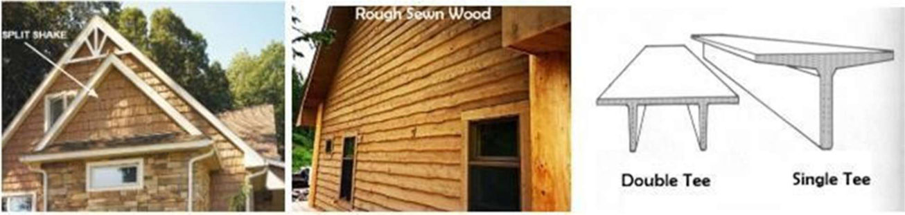
The following exterior materials are prohibited: split shakes, rough-sawn wood; concrete block; tilt-up concrete panels; field- painted or pre-finished standard corrugated metal siding; standard single- or double-tee concrete systems; or EIFS.
- iii.
These guidelines are not intended to inhibit creativity and innovation in building design. Zoning Coordinator may permit the use of other materials if the applicant demonstrates that the use of such materials will result in a building that gives a sense of quality and permanence.
- i.
- c.
Roof Forms
- i.
On two- or three-story buildings, roofs should be residential in scale, incorporating a gable or hip configuration with dormers or other complementary elements. Roof design will be reviewed on an individual basis.
- ii.
Roofs shall effectively screen all rooftop mechanical equipment from public view.
- iii.
Visible roof materials shall include clay or concrete tile, standing seam metal, architectural grade asphalt shingles, architectural metals, copper, natural or synthetic slate, or similar durable materials.
- iv.
Green roofs, as a storm water BMP and consistent with industry standards, are encouraged to be utilized in combination with other storm water BMPs.
- i.
- a.
- 1.
8.05 FF/FW Flood Fringe/Floodway Overlay District
This zoning district is created for meeting the needs of the watercourses and drainage ways and the conveyance of floodwaters in the County and to minimize the extent of floods and reduce the height and violence thereof; to promote health, safety, and the general welfare of the County; and to secure safety from floods.
- B.
FINDINGS OF FACT
- 1.
Flood losses resulting from periodic inundation. The flood hazard areas of Douglas County, Nebraska, are subject to inundation, which results in loss of life and property, health and safety hazards, disruption of commerce and governmental services, extraordinary public expenditures for flood protection and relief, and impairment of the tax base, all of which adversely affect the public health, safety, and general welfare.
- 2.
General Causes of the Flood Losses. These flood losses are caused by: (1) the cumulative effect of obstructions in floodplains causing increases in flood height and velocities; and (2) the occupancy of flood hazard areas by uses vulnerable to flood or hazardous to others, which are inadequately elevated or otherwise unprotected from flood damage.
- 3.
Methods Used to Analyze Flood Hazards. This regulation uses a reasonable method of analyzing flood hazards, which consists of a series of interrelated steps.
- a.
Selection of a regulatory base flood, which is based upon engineering calculations that permit a consideration of such flood factors as its expected frequency of occurrence, the area inundated, and the depth of inundation. The base flood is representative of large floods, which are reasonably characteristic of what can be expected to occur on the particular streams subject to this regulation. It is in the general order of a flood which could be expected to have a one percent (1%) chance of occurrence in any one year, as delineated on the Federal Insurance Administration’s Flood Insurance Study and illustrative materials dated May 19, 2014, as amended and any future revisions thereto.
- b.
Calculation of water surface profiles on a hydraulic engineering analysis of the capacity of the stream channel and overbank areas to convey the base flood.
- c.
Computation of the floodway required to convey this flood without increasing flood heights more than one (1) foot at any point.
- d.
Delineation of floodway encroachment lines within which no obstruction is permitted, which would cause any water surface increase along the floodway profile.
- e.
Delineation of the floodway fringe, i.e., that area outside the floodway encroachment lines, but which is still subject to inundation by the base flood.
- a.
- 4.
Statement of Purpose. It is the purpose of this regulation to protect the public health, safety, and general welfare and to minimize those losses described in Section B(1), by applying the provisions of this regulation to:
- a.
Restrict or prohibit uses that are dangerous to health, safety, or property in times of flooding or cause undue increases in flood heights or velocities.
- b.
Require that uses vulnerable to floods, including public facilities that serve such uses, be provided with flood protection at the time of initial construction.
- c.
Assure that eligibility is maintained for property owners in the community to purchase flood insurance in the National Flood Insurance Program.
- a.
- 1.
Section 8.05.1 General Provisions
- A.
Lands to which this regulation applies. This regulation shall apply to all lands within the zoning jurisdiction of the County of Douglas, Nebraska identified on the Flood Insurance Rate Map (FIRM) panels 31055C0025H,31055C0135H, 31055C0165H, and 31055C0280H dated December 2, 2005; and 31055C0154J, 31055C0155J, and 31055C0160J dated May 19, 2014; 31055C0050J, 31055C0075J, 31055C0088J, 31055C0177K, 31055C0179K, 31055C0180J, and 31055C0285J dated March 25, 2025 and as amended, as Zones A, A1-30, AE, AO, or AH and within the floodway (FW) and flood fringe (FF) zoning districts based on the most restrictive information available. In all areas covered by this regulation, no development shall be permitted except upon the issuance of a floodplain development permit, granted by Douglas County, Nebraska or its duly designated representative under such safeguards and restrictions as Douglas County, Nebraska, or the designated representative may reasonably impose for the promotion and maintenance of the general welfare, health of the inhabitants of Douglas County, Nebraska.
- B.
The Enforcement Officer. The Stormwater and Floodplain Specialist of Douglas County, Nebraska, is hereby designated as the County’s duly designated enforcement officer under this regulation.
- C.
Rules for Interpretation of District Boundaries. The boundaries of the floodway and flood fringe overlay districts shall be determined by scaling distances on the official zoning map. Where interpretation is needed to determine the exact location of the boundaries of the FW and FF districts, as shown on the County’s zoning map (e.g., where there appears to be a conflict between a mapped boundary and actual field conditions) the Enforcement Officer shall make the necessary interpretation. In such cases where the interpretation is contested, the Douglas County Board of Adjustment will resolve the dispute. The regulatory floodway elevation for the point in question shall be the governing factor in locating the district boundary on the land. The location of the floodway overlay district boundary may be based on a map completed or approved by the County or other government agency, provided the boundary is not less restrictive than that shown on the effective FIRM. The person contesting the location of the district boundary shall be given a reasonable opportunity to present his/her case to the Douglas County Board of Adjustment and to submit his/her own technical evidence if he/she so desires.
- D.
Compliance. Within identified special flood hazard areas of this community, no development shall be located, extended, converted, or structurally altered without full compliance with the terms of this regulation and other applicable regulations.
- E.
Abrogation and Greater Restrictions. It is not intended by this regulation to repeal, abrogate, or impair any existing easements, covenants, or deed restrictions. However, where this regulation imposes greater restrictions, the provision of the regulation shall prevail.
- F.
Interpretation. In their interpretation and application, the provisions of this regulation shall be held to be minimum requirements.
- G.
Warning and Disclaimer of Liability. The degree of flood protection required by this regulation is considered reasonable for regulatory purposes and is based on engineering and scientific methods of study. Larger floods may occur, or the flood height may be increased by man-made or natural causes such as ice jams and bridge openings restricted by debris. This regulation does not imply that areas outside floodway and flood fringe district boundaries or land uses permitted within such districts will be free from flooding or flood damage. This regulation shall not create liability on the part of Douglas County, Nebraska, or any officer or employee thereof for any flood damages that may result from reliance on this regulation or any administrative decision lawfully made thereafter.
- H.
Severability. If any section, clause, provision, or portion of this regulation is adjudged unconstitutional or invalid by a court of competent jurisdiction, the remainder of this regulation shall not be affected thereby.
- I.
Appeal. Where a request for a floodplain development permit is denied by the Enforcement Officer, the applicant may apply for such permit or variance directly to the Douglas County Board of Adjustment.
Section 8.05.2 Floodplain Development Permit
- A.
Permit Required. No person, firm, or corporation shall initiate any floodplain development or substantial improvement or cause the same to be done without first obtaining a separate permit for development as defined in Section 8.05.12.
- B.
Administration.
- 1.
The Enforcement Officer is hereby appointed to administer and implement the provisions of this regulation.
- 2.
Duties of the Enforcement Officer shall include, but not be limited to:
- a.
Review and approve or deny all applications for floodplain development permits.
- b.
Reviewing all development permit applications to ensure that sites are reasonably safe from flooding and that the requirements of this regulation have been satisfied.
- c.
Reviewing applications for proposed development to ensure that all necessary permits have been obtained from those Federal, State, or Local governmental agencies from which prior approval is required.
- d.
Review all subdivision proposals and other proposed new developments, including manufactured home parks or subdivisions, to determine whether such proposals will be reasonably safe from flooding.
- e.
Notify adjacent communities, the U.S. Army Corps of Engineers, and the Nebraska Department of Natural Resources prior to any alteration or relocation of a watercourse and submit evidence of such notification to the Federal Emergency Management Agency.
- f.
Assure that maintenance is provided within the altered or relocated portion of the watercourse so that the flood carrying capacity is not diminished.
- g.
Verifying, recording, and maintaining records of the actual elevation (in relation to mean sea level) of the lowest floor (including basement) of all new or substantially improved structures in the special flood hazard areas.
- h.
Verifying, recording, and maintaining records of the actual elevation (in relation to mean sea level) to which new or substantially improved non- residential structures have been flood-proofed.
- i.
When flood-proofing is utilized for a particular structure, the Enforcement Officer shall be presented with certification from a registered professional engineer or architect.
- j.
Verify, record, and maintain a record of all improved or damaged structures to ensure compliance with standards in applicable sections. Record the value of improvements and market value with permits. Also, ensure consistent market value estimations to evaluate against damaged or improved values.
- k.
Maintaining all records of all floodplain development permits and/or building permits within the floodway or flood fringe overlay district.
- a.
- 1.
- C.
Application for Permit. To obtain a floodplain development permit, the applicant shall first file an electronic application in the online permit portal. Every such application shall:
- 1.
Identify and describe the development to be covered by the floodplain development permit.
- 2.
Describe the land on which the proposed development is to be done by lot, block, tract, house, and street address, or a similar description that will readily identify and definitely locate the proposed building or development.
- 3.
Indicate the use or occupancy for which the proposed development is intended.
- 4.
Be accompanied by plans and specifications for proposed construction, including, but not limited to, the following information:
- a.
1) existing (natural) grades,
- b.
2) proposed grades as a result of proposed development,
- c.
3) the proposed lowest floor elevation and any higher floor elevations,
- d.
4) the lowest and highest adjacent grades next to any proposed structures, and
- e.
5) the most restrictive base flood elevation nearest the proposed development.
- a.
- 5.
Be signed by the permittee or his/her authorized agent, who may be required to submit evidence to indicate such authority.
- 6.
Give such other information as reasonably may be required by the Enforcement Officer.
- 7.
Comments from the Papio-Missouri River Natural Resources District will be solicited by Douglas County concerning each application for a flood plain development permit.
- 1.
Section 8.05.3 Establishment of Zoning Districts
Along watercourses where a floodway has been established, the mapped floodplain areas are hereby divided into the two following districts: A Floodway Overlay district (FW) and a Flood Fringe Overlay District (FF), both as identified in the Flood Insurance Studies (FIS); 31055CV001E, 31055CV002E, 31055CV003E, and 31055CV004E effective March 25, 2025, FIRM, or best available data. The zoning districts created by this regulation overlie other zoning districts and place additional restrictions upon the manner in which lands in such underlying districts may be used. Within the FF and FW districts all uses not meeting the standards of this regulation and those standards of the underlying zoning district shall be prohibited.
Section 8.05.4 Standards for Floodplain Development
- A.
No permit for development shall be granted for new construction, substantial improvements, and other development(s), including the placement of manufactured homes within all numbered and unnumbered A zones (including AE, AO, and AH zones) unless the conditions of this regulation are satisfied.
- B.
All areas identified as unnumbered A zones on the FIRM are subject to inundation of the base flood; however, the water surface elevation is not provided. The unnumbered A zones shall be subject to all development provisions of Section 8.05.5. If the Flood Insurance Study data is not available, Douglas County shall utilize any base flood elevation or floodway data currently available from Federal, State, or other sources.
- C.
Where a floodway has not been designated, no development or substantial improvement may be permitted within special flood hazard areas unless the applicant has demonstrated that the proposed development or substantial improvement, when combined with all other existing and reasonably anticipated developments or substantial improvements, will not increase the water surface elevation of the base flood more than one (1) foot at any location as shown on the FIRM or best available data.
- D.
New development shall require:
- a.
Design or anchorage to prevent floating, collapse, or lateral movement of the structure resulting from hydrodynamic and hydrostatic loads, including the effects of buoyancy.
- b.
New or replacement water supply systems and sanitary sewage systems should be designed to minimize or eliminate infiltration of flood waters into the systems and discharges from the systems into flood waters, and on-site waste disposal systems should be located so as to avoid impairment or contamination.
- c.
Construction with materials resistant to flood damage, utilizing methods and practices that minimize flood damage, and with electrical, heating, ventilation, plumbing, and air conditioning equipment and other service facilities that are designed and/or located to prevent water from entering or accumulating within the components during flood conditions.
- d.
All electrical equipment and sanitary facilities, including circuits, installed electric appliances, toilets, sinks, and drains in new developments and substantial improvements shall be located so as not to be subject to flooding or elevated two (2) feet above the base flood elevation. Backflow valves shall be installed on all septic lines leading from the structure.
- e.
Storage of Material and Equipment
- i.
The storage or processing of materials that are in time of flooding, buoyant, flammable, explosive, or could be injurious to human, animal, or plant life, is prohibited.
- ii.
Storage of other material or equipment may be allowed if not subject to major damage by floods and firmly anchored to prevent flotation, or if readily removable from the area within the time available after a flood warning.
- i.
- f.
Subdivision proposals and other proposed new developments, including manufactured home parks or subdivisions, will be required to ensure that:
- i.
All such proposals are consistent with the need to minimize flood damage.
- ii.
All public utilities and facilities, such as sewer, gas, electrical, and water systems, are installed to minimize or eliminate flood damage.
- iii.
Adequate drainage is provided so as to reduce exposure to flood hazards; and
- iv.
Proposals for development (including proposals for manufactured home parks and subdivisions) of five (5) acres or fifty (50) lots, whichever is less, and where base flood elevation data are not available, shall be supported by hydrologic and hydraulic analyses that determine base flood elevations and floodway information. The analyses shall be prepared by a licensed professional engineer in the format required by FEMA for Conditional Letters of Map Revision and a Letter of Map Revision.
- i.
- a.
Section 8.05.5 Flood Fringe Overlay district (Including AO and AH Zones)
- A.
Permitted Uses. No use shall be permitted in the district unless the standards of section 8.05.4 are met.
- B.
Standards for the Flood Fringe Overlay District.
- 1.
New construction or substantial improvements of residential structures shall have the lowest floor, including basement, elevated a minimum of two (2) feet above the base flood elevation.
- 2.
New construction or substantial improvements of commercial, industrial, and other non-residential structures shall have the lowest floor, including basement, elevated a minimum of two (2) feet above the base flood elevation or, together with attendant utility and sanitary facilities, to be flood-proofed so that below that level the structure is watertight with walls substantially impermeable to the passage of water and with structural components having the capability of resisting hydrostatic and hydrodynamic loads and effects of buoyancy. A registered professional engineer or architect shall certify that the standards of this subsection are satisfied. Such certification shall be provided to the Enforcement Officer as set forth in section 8.05.2
- a.
Structures accessory to a principal building may have the lowest floor below two (2) feet above the base flood elevation, provided that the structure complies with the following requirements:
- i.
The structure shall not be used for human habitation.
- ii.
The use of the structure must be limited to parking of vehicles or storage of items readily removable in the event of a flood warning.
- iii.
The floor area shall not exceed 400 square feet.
- iv.
The structure shall have a low damage potential.
- v.
The structure must be adequately anchored to prevent floatation, collapse, or other lateral movement.
- vi.
The structure shall be designed to automatically provide for the entry and exit of floodwaters for the purpose of equalizing hydrostatic forces. Designs for meeting this requirement must be certified by a registered professional engineer or architect or meet or exceed the following minimum criteria:
- i.
- a.
A minimum of two openings having a net area of not less than one (1) square inch for every one (1) square foot of enclosed space,
- b.
The bottom of all openings shall not be higher than two (2) feet above grade, and
- c.
Openings may be equipped with screens, louvers, valves, or other coverings or devices, provided that they allow the automatic entry and exit of floodwaters.
- vii.
No utilities shall be installed except electrical fixtures in the structure, which must be elevated to or above two (2) feet above the base flood elevation or flood proofed so that below two (2) feet above the base flood elevation they are:
- a.
Watertight and substantially impermeable to the passage of water; and,
- b.
Capable of resisting hydrostatic and hydrodynamic loads and effects of buoyancy.
- c.
A registered professional engineer or architect shall certify that the standards of this subsection are satisfied. A floodproofing certificate shall be provided to the floodplain administrator.
- viii.
The structure shall be constructed and placed on the building site so as to offer the minimum resistance to the flow of floodwaters.
- ix.
If the structure is converted to another use not consistent with the restrictions in this section, it must be brought into full compliance with the minimum standards governing such use.
- b.
Agricultural structures may have the lowest floor less than two (2) feet above the base flood elevation, provided that a variance is authorized to be issued for the construction or substantial improvement of agricultural structures and the requirements of this section and the following are satisfied:
- i.
Is used exclusively in connection with the production, harvesting, storage, raising, or drying of agricultural commodities and livestock, or storage of tools or equipment used in connection with these purposes or used, and will be restricted to such exclusive uses.
- ii.
Has low damage potential (amount of physical damage, contents damage, and loss of function).
- iii.
Does not increase risks and pose a danger to public health, safety, and welfare if flooded and contents are released, including but not limited to the effects of flooding on manure storage, livestock confinement operations, liquefied natural gas terminals, and production and storage of highly volatile, toxic, or water- reactive materials.
- iv.
Complies with the wet flood proofing construction requirements of this regulation.
- v.
The structure shall not be used for human habitation.
- vi.
The use of the structure should be limited to the storage of items readily removable in the event of a flood warning.
- vii.
The structure shall be designed with an unfinished interior and constructed with flood damage-resistant materials following the County’s adopted building code.
- viii.
The structure must be adequately anchored to prevent flotation, collapse, or other lateral movements following the County’s adopted building code.
- ix.
The structure shall be designed to automatically provide for the entry and exit of floodwaters for the purpose of equalizing hydrostatic forces. Designs for meeting this requirement must be certified by a registered professional engineer or architect.
- x.
No utilities shall be installed except electrical fixtures in the structure, which must be elevated or flood-proofed to a minimum of two (2) feet above the base flood elevation.
- xi.
The structure shall be constructed and placed on the building site so as to offer the minimum resistance to the flow of floodwaters.
- xii.
The site where the building is proposed must be a minimum of 80 acres in size, and the entirety of the property in the Special Flood Hazard Area, unless otherwise allowed in the zoning regulations.
- xiii.
The site where the building is proposed shall be on the same land parcel as the agricultural operation it is serving.
- i.
- a.
- 3.
All new construction and substantial improvements with fully enclosed areas below the lowest floor cannot be used for human habitation and can only be used for parking of vehicles, building access, or storage in an area other than a basement, and which are subject to flooding shall be designed to automatically equalize hydrostatic flood forces on exterior walls by allowing for the entry and exit of floodwaters. The area below the lowest floor subject to flooding shall be a maximum of four (4) feet in height measured from the bottom of the floor joists, unless used for parking of vehicles. When the area below the lowest floor is used for the parking of vehicles, the County may require the owner to sign a nonconversion agreement and file it with the Register of Deeds. A nonconversion agreement may only be used for attached garages or parking areas below elevated buildings at the discretion of the County. Designs for meeting this requirement must be certified by a registered professional engineer or architect or meet or exceed the following minimum criteria: A minimum of two openings having a total net area of not less than one square inch for every square foot of enclosed area subject to flooding shall be provided. The bottom of all openings shall not be higher than one foot above grade. Openings may be equipped with screens, louvers, valves, or other coverings or devices provided that they permit the automatic entry and exit of floodwaters.
- 4.
The storage or processing of materials, that are in a time of flooding buoyant, flammable, explosive, or which could then become injurious to human, animal, or plant life, is prohibited; however, storage of other material or equipment may be allowed if such is not subject to major damage by floods and firmly anchored to prevent flotation or if such is readily removable from the area within 24 hours after flood warning.
- 5.
Subdivision proposals shall assure that: a.) all such proposals and other proposed new development, including manufactured home parks or subdivisions, are consistent with the need to minimize flood damage; b.) all public utilities and facilities, such as sewer, gas, electrical, and water systems are located, elevated, and constructed to minimize or eliminate flood damage; c.) adequate drainage is provided so as to reduce exposure to flood hazards; and d.) proposals for development (including proposals for manufactured home parks and subdivisions) of five (5) acres or fifty (50) lots, whichever is less, where base flood elevation data are not available, shall be supported by hydrologic and hydraulic analyses that determine base flood elevations and floodway information. The analyses shall be prepared by a licensed professional engineer in the format required by FEMA for Conditional Letters of Map Revision and a Letter of Map Revision.
- 6.
Located within the areas of special flood hazard areas established in section 8.05.1(A) are areas designated as AO Zones. These areas have special flood hazards associated with base flood depths of one to three feet where a clearly defined channel does not exist and where the path of flooding is unpredictable and indeterminate; therefore, the following provisions apply within AO Zones: all new construction and substantial improvements of residential structures shall have the lowest floor, including basement, elevated above the highest adjacent grade a minimum of two (2) feet above the depth number specified in feet on the Douglas County FIRM (and a minimum of three feet if no depth number is specified). All new construction, cumulative substantial improvement, and substantial improvements of non-residential structures shall have the lowest floor elevated above the highest adjacent grade a minimum of at least two foot above the depth number specified in feet on the community’s FIRM (at least three feet if no depth number is specified); or together with attendant utility and sanitary facilities to be completely flood proofed to or above that level so that any space below that level is watertight with wall substantially impermeable to the passage of water and with structural components having the capability of resisting hydrostatic and hydrodynamic loads and effects of buoyancy. Certification shall be provided to the Enforcement Officer.
- 7.
Within all zones, adequate drainage paths around structures on slopes shall be required in order to guide floodwaters around and away from proposed structures.
- 8.
Manufactured Homes.
- a.
All manufactured homes shall be anchored to resist floatation, collapse, or lateral movement. Manufactured homes must be anchored in accordance with the County-adopted building codes. In the event that over-the-top frame ties to ground anchors are used, the following specific requirements (or their equivalent) shall be used:
- i.
Over-The-Top ties be provided at each of the four (4) corners of the manufactured home, with two (2) additional ties per side at intermediate locations with manufactured homes less than fifty (50) feet long requiring one (1) additional tie per side.
- ii.
Frame ties be provided at each corner of the home with five (5) additional ties per side at intermediate points, with manufactured homes less than fifty (50) feet long requiring four (4) additional ties per side.
- iii.
All components of the anchoring system are capable of carrying a force of 4800 pounds, and any additions to the manufactured home are similarly anchored.
- i.
- b.
Require all manufactured homes to be placed or substantially improved within special flood hazard areas on the community FIRM on sites:
- i.
Outside of a manufactured home park or subdivision.
- ii.
In a new manufactured home park or subdivision.
- iii.
In an expansion to an existing manufactured home park or subdivision, or
- iv.
In an existing manufactured home park or subdivision on which a manufactured home has incurred “substantial damage” as a result of a flood, be elevated on a permanent foundation such that the lowest floor of the manufactured home is at or above two (2) feet above the base flood elevation; and be securely anchored to an adequately anchored foundation system in accordance with the provisions of this regulation.
- v.
Have adequate surface drainage and access for a hauler to be provided at each lot; and require all stands or lots to be of an elevation such that the lowest floor of the manufactured home be placed thereupon, will be two (2) feet above the base flood elevation.
- vi.
Where such an elevation is attained through the use of piers rather than compacted fill, the lots shall be large enough to permit the installation of steps, pier foundations shall be placed on stable soil no more than ten (10) feet apart, and steel reinforcement shall be provided for piers more than six (6) feet high.
- i.
- c.
Require that all manufactured homes to be placed within Zones “A”, “AO”, “AH”, and “AE” on the Douglas County FIRM, be elevated on a permanent foundation such that the lowest floor of the manufactured home is at least two (2) feet above the base flood elevation; and be securely anchored to an adequately anchored foundation system in accordance with the provisions of this regulation.
- a.
- 9.
Recreational vehicles placed on sites within the special flood hazard areas on the community’s official map shall either:
- a.
Be on site for fewer than one hundred eighty (180) consecutive days.
- b.
Be fully licensed and ready for highway use. A recreational vehicle is ready for highway use if it is on wheels or a jacking system, is attached to the site only by quick-disconnect type utilities and security devices, and has no permanently attached additions.; or
- c.
Meet the permit requirements and the elevation and anchoring requirements for “manufactured homes” of this regulation.
- a.
- 1.
Section 8.05.6 Floodway Overlay District
- A.
Permitted uses. Only uses having a low flood-damage potential and not obstructing flood flows shall be permitted within the floodway district to the extent that they are not prohibited by any other regulation. The following are the only permitted uses within the floodway district:
- a.
Open space uses not requiring a closed building, such as agricultural cropland, livestock feeding, and grazing, or open public and private recreation areas.
- b.
Wire fences, walls, or other appurtenances constructed in a way that would not constitute an obstruction or debris-catching obstacle to the passage of floodwaters.
- c.
Railroads, streets, bridges, public utility wires, and pipelines for transmission and local distribution.
- d.
Commercial excavation of materials from pits, strips, or pools; provided that no stockpiling of materials, products, or overburden shall be such as to create a potential restriction to the passage of floodwaters.
- e.
Non-restrictive improvements in stream channel alignment, cross-section, and capacity in the normal maintenance thereof.
- f.
Recreational vehicles may be placed on sites within the special flood hazard area on the County’s zoning map and shall be on site only between April 1 and October 31 for fewer than 180 consecutive days and be fully licensed and ready for highway use. A recreational vehicle is ready for highway use if it is on wheels or a jacking system, is attached to the site only by quick-disconnect type utilities and security devices, and has no permanently attached additions. In all cases, the recreational vehicle must comply with the requirements of section 8.05. Recreational vehicles shall not be allowed on any site between November 1 and March 31.
- a.
- B.
Standards for the Floodway Overlay District. New structures for human habitation are prohibited. All encroachments, including fill, new construction, substantial improvements, and other development, are prohibited unless certification by a registered professional engineer is provided demonstrating that the development shall not result in any increase in water surface elevations along the floodway profile during the occurrence of the base flood discharge. These uses are subject to the standards of sections 8.05.3 and 8.05.4. In Zone A unnumbered, obtain, review, and reasonably utilize any flood elevation and floodway data available through Federal, State, or other sources of this regulation, in meeting the standards of this section.
Section 8.05.7 Variance Procedures
- A.
The Board of Adjustment, as established by Douglas County, shall hear and decide appeals and requests for variances from the requirements of this regulation.
- B.
The Board of Adjustment shall hear and decide appeals when it is alleged that there is an error in any requirement, decision, or determination made by the Enforcement Officer in the enforcement or administration of this regulation.
- C.
Any person aggrieved by the decision of the Board of Adjustment or any taxpayer may appeal such decision to the District Court as provided in Section 23-168.02, R.R.S. 1943
- D.
In passing upon such application, the Board of Adjustment shall consider all technical evaluations, all relevant factors, and standards specified in other sections of this regulation, and
- a.
The danger that materials may be swept onto other lands to the injury of others.
- b.
The danger to life and property due to flooding or erosion damage.
- c.
The susceptibility of the proposed facility and its contents to flood damage, and the effect of such damage on the individual owner.
- d.
The importance of the services provided by the proposed facility to the community.
- e.
The necessity to the facility of a waterfront location, where applicable.
- f.
The availability of alternative locations, not subject to flooding or erosion damage, for the proposed use.
- g.
The compatibility of the proposed use with existing and anticipated development.
- h.
The relationship of the proposed use to the comprehensive plan and floodplain management program for that area.
- i.
The safety of access to the property during a flood for ordinary and emergency vehicles.
- j.
The expected heights, velocity, duration, rate of rise, and sediment transport of the floodwaters and the effects of wave action, if applicable, are expected at the site.
- k.
The costs of providing governmental services during and after flood conditions, including maintenance and repair of public utilities and facilities such as sewer, gas, electrical, and water systems, and streets and bridges.
- a.
Section 8.05.8 Conditions for Variances
- A.
Generally, variances may be issued for new construction and substantial improvements to be erected on a lot of one-half acre or less in size, contiguous to and surrounded by lots with existing structures constructed below the base flood level, providing items (B-F below) have been fully considered. As the lot size increases beyond the one-half acre, the technical justification required for issuing variances increases.
- B.
Variances may be issued for the repair or rehabilitation of historic structures upon a determination that the proposed repair or rehabilitation will not preclude the structure’s continued designation as a historic structure and that the variance is the minimum necessary to preserve the historic character and design of the structure.
- C.
Variances shall not be issued within any designated floodway if any increase in flood levels along the floodway during the base flood discharge would result.
- D.
Variances shall only be issued upon a determination that the variance is the minimum necessary, considering the flood hazard, to afford relief.
- E.
Variances shall only be issued upon:
- a.
A showing of good and sufficient cause.
- b.
A determination that failure to grant the variance would result in exceptional hardship to the applicant, and
- c.
A determination that the granting of a variance will not result in increased flood heights, additional threats to public safety, extraordinary public expense, create nuisances, cause fraud on or victimization of the public, or conflict with existing local laws or regulations.
- a.
- F.
The applicant shall be given a written notice over the signature of a community that the issuance of a variance to construct a structure below the base flood elevation will result in increased premium rates for flood insurance up to amounts as high as $25 for $100 of insurance coverage, and also that such construction below the base flood elevation increases risks to life and property. Such notification shall be maintained with the record of all variance actions as required by this ordinance.
Section 8.05.9 Non-Conforming Use
This requirement is to provide for the regulation of non-conforming uses of buildings, structures, or lands and to specify those circumstances and conditions under which those non-conforming uses or buildings, structures, or lands shall be allowed to remain as legal non-conforming uses or shall be terminated as a non-conforming use.
- A.
Any non-conforming use of buildings, structures, or lands which existed lawfully at the time of adoption of these regulations, and which remains non-conforming, and any such building, structure, or land which shall become non-conforming upon the adoption of these regulations, or of any subsequent amendment thereto, may be continued subject to the following conditions:
- a.
No such structure or use shall be expanded, changed, enlarged, or altered in a way that increases its nonconformity.
- b.
If such use is discontinued for twelve (12) consecutive months, any future use of the building premises shall conform to this regulation.
- c.
Uses or adjuncts thereof that are or become nuisances shall not be entitled to continue as nonconforming uses.
- a.
- B.
If, in the determination of the Enforcement Officer, any nonconforming use or structure is destroyed by any means, including flood, it shall not be reconstructed if the cost is more than fifty (50) percent of the market value of the structure before the damage occurred, except that if it is reconstructed in conformity with the provisions of this regulation. This limitation does not include the cost of any alteration to comply with existing state or local health, sanitary, building, or safety codes or regulations or the cost of any alteration of a structure listed on the National Register of Historic Places or State Inventory of Historic Places, provided that the alteration shall not preclude its continued designation.
Section 8.05.10 Penalties for Violation
Violation of the provisions of this regulation or failure to comply with any of its requirements (including violations of conditions and safeguards established in connection with grants of variances or special exceptions) shall constitute a Class III misdemeanor according to Nebraska Revised Statutes Sec. 23-174. Any person, firm, corporation, or other entity that violates this ordinance or fails to comply with any of its requirements shall, upon conviction thereof, be fined not more than $500, and in addition, shall pay all costs and expenses involved in the case. Each day such a violation continues after notice of violation has been given to the offender shall be considered a separate offense.
Nothing herein contained shall prevent the County from taking such other lawful action as is necessary to prevent or remedy any violation. Any of the following acts shall constitute a violation: 1) development, improvement or substantial improvement with a floodplain development permit if one is required by the provisions of this regulation, 2) continuing a development, improvement or substantial improvement after the floodplain development permit for such has been duly revoked if it was required by the provisions of this regulation, and 3) deviating substantially from the terms of an application for a floodplain development permit as those terms were accepted by the Douglas County Department of Environmental Services.
When the floodplain administrator or other authorized community representative determines, based on reasonable grounds, that there has been a violation of the provisions of this ordinance, the floodplain administrator shall give notice of such alleged violation as hereinafter provided. Such notice shall:
- a.
Be in writing;
- b.
Include an explanation of the alleged violation.
- c.
Allow a reasonable time for the performance of any remedial act required.
- d.
Be served upon the property owner or their agent, as the case may require; and
- e.
Contain an outline of remedial actions that, if taken, will bring the development into compliance with the provisions of this regulation.
Section 8.05.11 Amendments
The regulations, restrictions and boundaries set forth in this regulation may from time to time be amended, supplemented, changed or appealed to reflect any and all changes in the National Flood Disaster Protection Act of 1973, provided, however, that no such action may be taken until after a public hearing in relation thereto, at which parties in interest and citizens shall have an opportunity to be heard. Notice of the time and place of such hearing shall be published in a newspaper of general circulation in Douglas County, Nebraska. At least fourteen (14) days shall elapse between the date of this publication and the public hearing. A copy of such amendments will be provided to the Federal Emergency Management Agency. A copy of such amendments will be provided to the Federal Emergency Management Agency. This Regulation is in compliance with the National Flood Insurance Program Regulations as published in Title 44 of the Code of Federal Regulations and the 1983 Nebraska Flood Plain Management Act.
Section 8.05.12 Definitions
Unless specifically defined below, words or phrases used in this regulation shall be interpreted so as to give them the meaning they have in common usage and to give this regulation its most reasonable application.
ACCESSORY STRUCTURE means a structure with no more than one story on the same parcel of property as the principal structure, the use of which is incidental to the use of the principal structure. Also shall be known as “appurtenant structure.”
AGRICULTURAL STRUCTURE for floodplain management purposes shall mean a walled and roofed structure used exclusively for agricultural purposes or used in connection with the production, harvesting, storage, raising, or drying of agricultural commodities and livestock, including aquatic organisms. Structures that house tools or equipment used in connection with these purposes or uses are also considered to have agricultural purposes or uses.
APPEAL means a request for a review of the Zoning Administrator’s interpretation of any provision of this regulation or a request for a variance.
AREA OF SHALLOW FLOODING means a designated AO or AH zone on a community’s Flood Insurance Rate Map (FIRM) with a one (1) percent or greater annual chance of flooding to an average depth of one (1) to three (3) feet where a clearly defined channel is unpredictable and where velocity flow may be evident. Such flooding is characterized by ponding or sheet flow.
BASE FLOOD means the flood having a one (1) percent chance of being equaled or exceeded in any given year.
BASE FLOOD ELEVATION (BFE) means the flood having a one (1) percent chance of being equaled or exceeded in any given year.
BASEMENT means any area of the building having its floor subgrade (below ground level) on all sides.
DEVELOPMENT means any man-made change to improved or unimproved real estate, including but not limited to buildings or other structures, mining, dredging, filling, grading, paving, excavation, or drilling operations, or storage of equipment or materials.
EXISTING CONSTRUCTION means (for the purposes of determining rates) structures for which the “start of construction” commenced before the effective date of the FIRM or Before January 1, 1975, for FIRMs effective before that date. “Existing construction may also be referred to as “existing structures.”
EXISTING MANUFACTURED HOME PARK OR SUBDIVISION means a manufactured home park or subdivision for which the construction of facilities for servicing the lots on which the manufactured homes are to be affixed (including, at a minimum, the installation of utilities, the construction of streets, and either final site grading or the pouring of concrete pads) is complete before the effective date of the floodplain management regulations adopted by a community.
EXPANSION TO AN EXISTING MANUFACTURED HOME PARK OR SUBDIVISION means the preparation of additional sites by the construction of facilities for servicing the lots on which the manufactured homes are to be affixed (including the installation of utilities, the construction of streets, and either final site grading or the pouring of concrete pads).
FLOOD OR FLOODING means a general and temporary condition of partial or complete inundation of normally dry land areas from: The overflow of inland or tidal waters or the usual and rapid accumulation of runoff of surface waters from any source.
FLOOD FRINGE is that area of the floodplain, outside of the floodway, that on the average is likely to be flooded once every 100 years (i.e., that has a one (1) percent chance of flood occurrence in any one year)
FLOOD INSURANCE RATE MAP (FIRM) means an official map of a community, on which the Flood Insurance Study has delineated the Flood Hazard Boundaries and the zones establishing insurance rates applicable to the community.
FLOOD INSURANCE STUDY (FIS) is the official report provided by the Federal Emergency Management Agency. The report contains flood profiles, as well as the Flood Boundary Floodway Map and the water surface elevation of the base flood.
FLOODPLAIN means any land area susceptible to being inundated by water from any source (see definition of flooding).
FLOOD PROOFING means any combination of structural and non-structural additions. Changes or adjustments to structures that reduce or eliminate flood damage to real estate or improved real property, water and sanitary facilities, structures, and their contents.
FLOODWAY OR REGULATORY FLOODWAY means the channel of a river or other watercourse and the adjacent land areas that must be reserved in order to discharge the base flood without cumulatively increasing the water surface elevation more than one (1) foot.
FREEBOARD means a factor of safety usually expressed in feet above a flood level for purposes of floodplain management. “Freeboard” tends to compensate for the many unknown factors that could contribute to flood heights greater than the height calculated for a selected size flood and floodway conditions, such as wave action, clogged bridge openings, and the hydrological effect of urbanization of the watershed.
HIGHEST ADJACENT GRADE means the highest natural elevation of the ground surface prior to construction next to the proposed walls of a structure.
HISTORIC STRUCTURE means any structure that is:
- A.
Listed individually in the National Register of Historic Places (a listing maintained by the Department of the Interior) or preliminarily determined by the Secretary of the Interior as meeting the requirements for individual listing on the National Register.
- B.
Certified or preliminarily determined by the Secretary of the Interior as contributing to the historical significance of a registered historic district or a district preliminarily determined by the Secretary to qualify as a registered historic district.
- C.
Individually listed on a state inventory of historic places in states with historic preservation programs that have been approved by the Secretary of the Interior; or
- D.
Individually listed on a local inventory of historic places in communities with historic preservation programs that have been certified either.
- a.
By an approved state program as determined by the Secretary of the Interior or
- b.
Directly by the Secretary of the Interior in states without approved programs.
- a.
LOWEST FLOOR means the lowest floor of the lowest enclosed area (including basement). An unfinished or flood-resistant enclosure, usable solely for parking of vehicles, building access, or storage, in an area other than a basement area, is not considered a building’s lowest floor, provided that such enclosure is not built so as to render the structure in violation of the applicable non- elevation design requirements of this Regulation.
MANUFACTURED HOME means a structure, transportable in one or more sections, which is built on a permanent chassis and is designed for use with or without a permanent foundation when attached to the required utilities. The term “manufactured home” does not include a “recreational vehicle.”
MANUFACTURED HOME PARK OR SUBDIVISION means a parcel (or contiguous parcels) of land divided into two (2) or more manufactured home lots for rent or sale.
NEW CONSTRUCTION for floodplain management purposes, “new construction” means structures for which the “start of construction commenced on or after the effective date of the floodplain management regulation adopted by a community and includes any subsequent improvements to such structures.”
NEW MANUFACTURED HOME PARK OR SUBDIVISION means a manufactured home park or subdivision for which the construction of facilities for servicing the lots on which the manufactured homes are to be affixed (including at a minimum, the installation of utilities, the construction of streets, and either final site grading or the pouring of concrete pads) is completed on or after the effective date of floodplain management regulations adopted by a community.
NON-RESIDENTIAL STRUCTURE means a commercial or mixed-use building where the primary use is commercial or non-habitational. (44 CFR 59.1 “Non-residential building”)
100-YEAR FLOOD means the condition of flooding having a one (1) percent chance of annual occurrence.
OVERLAY DISTRICT is a district in which additional requirements act in conjunction with the underlying zoning district (s). The original zoning district designation does not change.
PRINCIPALLY ABOVE GROUND means that at least 51 percent of the actual cash value of the structure is above ground.
RECREATIONAL VEHICLE means a vehicle which is:
- A.
Built on a single chassis.
- B.
400 square feet or less when measured at the largest horizontal projections.
- C.
Designed to be self-propelled or permanently towable by a light-duty truck.
- D.
Designed primarily not for use as a permanent dwelling but as temporary living quarters for recreational, camping, travel, or seasonal use.
RESIDENTIAL STRUCTURE means a non-commercial building designed for habitation by one or more families or a mixed-use building that qualifies as a single-family, two-to-four family, or other residential building. (44 CFR 59.1 “Residential building”)
SPECIAL FLOOD HAZARD AREA is the land in the floodplain within a community subject to a one percent or greater chance of flooding in any given year.
START OF CONSTRUCTION (for other than new construction or substantial improvements under the Coastal Barrier Resources Act (Pub. L. 97-348) includes substantial improvement, and means the date the building permit was issued, provided the actual start of construction, repair, reconstruction, rehabilitation, addition, placement, or other improvement was within 180 days of the permit date. The actual start means the first placement of permanent construction of a structure on a site, such as the pouring of slab or footings, the installation of piles, the construction of columns, or any work beyond the stage of excavation; or the placement of a manufactured home on a foundation.
Permanent construction does not include land preparation, such as clearing, grading and filling; nor does it include the installation of streets and/or walkways; nor does it include excavation for a basement, footings, piers, or foundations or the erection of temporary forms; nor does it include the installation on the property of accessory buildings, such as garages or sheds not occupied as dwelling units or not part of the main structure. For a substantial improvement, the actual start of construction means the first alteration of any wall, ceiling, floor, or other structural part of a building, whether or not the alteration affects the external dimensions of the building.
STRUCTURE means a walled and roofed building that is principally above ground, as well as a manufactured home, and a gas or liquid storage tank that is principally above ground.
SUBSTANTIAL DAMAGE means damage of any origin sustained by a structure whereby the cost of restoring the structure to its condition before the damage occurred, when combined with any additional repairs or improvements within 5 years prior to the floodplain development permit application, would equal or exceed fifty (50) percent of the market value of the structure before the damage occurred.
SUBSTANTIAL IMPROVEMENT means any reconstruction, rehabilitation, addition, or other improvement of a structure, the cost of which equals or exceeds 50 percent of the market value of the structure before “start of construction” of the improvement. This includes structures that have incurred “substantial damage,” regardless of the actual repair work performed. The term does not, however, include either:
- A.
any project for improvement of a structure to correct existing violations of state or local health, sanitary, or safety code specifications which have been identified by the local code enforcement official and which are the minimum necessary to assure safe living conditions, or
- B.
any alteration of a “historic structure”, provided that the alteration will not preclude the structure’s continued designation as a “historic structure.”
VARIANCES is a grant of relief to a person from the requirements of this Regulation, which permits construction in a manner otherwise prohibited by this Regulation where specific enforcement would result in unnecessary hardship.
VIOLATION means a failure of a structure or other development to be fully compliant with the community’s floodplain management regulations.